
Generally speaking, “levee” is a dirty word among environmentalists. Most levees provide flood-protection to communities that never should have been built in a floodplain to begin with. In the process, they destroy vast numbers of wetlands by shutting them off from natural seasonal flood events, depriving them of both water and silt deposition.
Since removing flood protection from an established city is a political non-starter, the next best solution is to redesign levees to restore some level of healthy ecological function. That’s what has just happened in the city of West Sacramento, California.
On February 5, 2020, the West Sacramento Area Flood Control Agency received the Envision® Platinum Award for sustainable infrastructure from the Institute for Sustainable Infrastructure (ISI). The award was for the city’s Southport Levee Improvement Project (SLIP). This is West Sacramento’s first Envision award, and the nineteenth Envision-verified project in California.
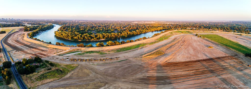
West Sacramento is seasonally surrounded by water and protected from flooding by the city’s levee system. This $180 million project, financed and constructed by the West Sacramento Area Flood Control Agency (WSAFCA), is the Agency’s largest capital improvement to date. Levee improvements along this 5.6-mile section include a combination of renovating the existing levee structure and the construction of a new setback levee.
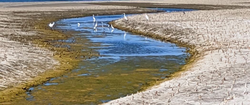
Wildlife returning to the restored areas. Geese, egrets, herons, and a bald eagle are among the species inhabiting the reestablished floodplain. (photo: WSAFCA)
Flood risk-reduction measures address deficiencies of through-seepage, under-seepage, slope stability and geometry, erosion, and encroachments and non-compliant vegetation. WSAFCA’s goal is to achieve a minimum 200-year level of levee performance for the entire West Sacramento levee system.
The project brings the levee into compliance with Federal and State levee design criteria, as well as providing opportunities for ecosystem restoration and public recreation. The project is relatively unique for an urban area in that it returns several hundred acres of land to riparian and oak savanna habitat.
This multi-benefit flood risk reduction and ecosystem restoration project was constructed as part of the federal West Sacramento Project, a partnership with the U.S. Army Corps of Engineers (USACE), WSAFCA, and the Central Valley Flood Protection Board acting through the Department of Water Resources (DWR) Division of Flood Management.
The City and WSAFCA worked in close collaboration with HDR, GEI Consultants, WSP, MBK Engineers, ICF International, SCS Engineers, AECOM, cbec and Blackburn Consulting to deliver this restorative award-winning project.
“This is a tremendous accomplishment for WSAFCA, our partners and the West Sacramento community and is a result of the project’s systematic planning, design, and delivery that, in addition to attaining flood risk reduction objectives, incorporated meaningful community, ecological, and tribal participation,” said WSAFCA Board President, Tom Ramos.
The Envision sustainable infrastructure framework assesses project sustainability across five categories: Quality of Life, Leadership, Resource Allocation, Natural World, and Climate and Resilience. These key areas contribute to positive social, economic, and environmental impacts on a community during the planning, design, and construction of infrastructure projects.
“The Southport Levee Improvement Project provides an intriguing design. The restoration of land to allow natural infiltration of stormwater provides both functional and environmental benefits to the community,” said Melissa Peneycad, ISI’s Managing Director. “As a Platinum award-winning project, this sustainable project truly presents innovation and best practices in its balanced delivery of environmental, social, and economic values.”
Factors contributing to the SLIP earning Envision Platinum include:
- Excellence in Cultural Engagement and Preservation – The project site was identified as being in an area with a high potential for buried cultural resources, particularly from indigenous tribes. Archeological surveys were conducted in advance of construction in collaboration with tribal monitors who also provided monitoring during construction. WSAFCA formulated a tribal wage/skill matrix to integrate tribal monitoring into the project as a technical skill set. The matrix can be used by others following this engaging practice. Ultimately, three sites were located in the project vicinity. Two sites were preserved in place and one site was moved but placed atop another with separation by soil and buffered from erosion.
- Multi-Benefit Infrastructure – The project’s primary goal is to ensure flood protection for residents and businesses of West Sacramento. The region anticipates a substantial increase in rainfall event intensity and high-water events in the coming decades. As such, the project was designed to contain a 200-year flood event or designed to withstand water levels with a 0.5% annual chance of occurrence. However, the project team considered several other ways the project could benefit the community, including increased recreational opportunities and habitat restoration. The project relocated a local road from the top of the levee thereby separating levee maintenance and flood fighting from the road’s use as an evacuation route. The levee crown now functions for levee management and serves as a trail for pedestrian/cyclist use. The trail links to a regional trail system, extended opportunities for exercise and views of the Sacramento River watershed.
- Habitat Mitigation – WSAFCA plans to complete levee system improvements over the next 5 years to meet a state-mandated 200-year level of flood protection, and some of those levee projects will likely not have feasible on-site opportunities for habitat mitigation. The project team maximized habitat restoration on the SLIP, restoring habitat in excess of regulatory requirements to offset future project impacts and to facilitate the planning process for other crucial flood-fighting efforts.
- Restoration of Natural Systems – The project’s restoration design increases river-floodplain connectivity and restores ecologically functional floodplain habitat consistent with the flood-risk reduction goals of the project. The project is restoring 212 acres of habitat, with a net increase of 114 acres of habitat that did not exist before the project. This includes new wetland habitat developed on the water side of the new levee to expand much-needed protected habitat for local biodiversity. The wetland is planted with a 100% native plant palette, including species that improve water quality such as California bulrush. Irrigation, which uses only river water, will be provided for plantings during a limited period. Once established, the plantings will have easy access to ground water, therefore the project has no long-term water use.
- Remediation of Contaminated and Degraded Areas – For the setback portion of the project to be successful, WSAFCA needed to ensure groundwater infiltration would not introduce contaminants into the watershed. To do this, the project team remediated two brownfield sites located within the project footprint. One site was remediated for arsenic and the other was a former tank farm with hydrocarbon contamination.
Featured photo of work in progress courtesy of SkyHigh Perspectives.