
Projects such as the High Line Park in New York City, New York and Discovery Green in Houston, Texas have upped the ante for cities, showcasing landscape architecture as a powerful tool for reconnecting urban dwellers with their water, their greenspace and their heritage.
When it’s done well, as in Pittsburgh, the ROI (return on investment) can be phenomenal: they turned $130 million of public investment into over $4 billion of mostly-private investment.
In many cases, this involved repurposing and renewing vacant or derelict properties, or—in the High Line Park’s case—vacant and derelict infrastructure. In other words, cities and landscape architects are embracing the 3Re Strategy for revitalization: repurposing, renewing, and reconnecting.
These projects—and many more like them—are a far cry from the pastoral, largely unprogrammed spaces championed in the last century by visionaries like Olmsted, Burnham, L’Enfant, Kessler, and Cleveland.
Today’s urban parks, instead, face intense pressure to provide “something to do” for an increasingly wide array of users—and are often, by necessity, thrust into new management and operational structures (think: conservancy or public/private partnership models).
For the first time in history, the majority of the world’s population lives in urban areas. Since the average city apartment’s footprint is significantly smaller than that found in suburbia, urban public spaces increasingly serve as an expansion of one’s apartment. The city, in essence, becomes one giant shared front yard.
Three American cities—Chicago, Illinois, Pittsburgh, Pennsylvania, and Cincinnati, Ohio—have made significant investments in one particular facet of public realm improvement: their riverfronts.
In many Midwest and Rust Belt cities of the United States, the pressure to attract and retain workers and create a better quality of life coupled with the declining use of waterways for industrial purposes has made riverfront revitalization a somewhat common strategy.
In Chicago, the desire to have a continuous Riverwalk along the Main Branch of the Chicago River has been a decades-long planning and design effort. In the 1990s, Chicago’s Department of Transportation created plans for a new continuous walkway—one that would require a 25-foot (7.6 m) extension of new land into the river and a series of “under-bridge” connections.
Envisioned as a mix of recreational, entertainment, food and beverage, and retail facilities, the Riverwalk is now a vibrant area enjoyed by residents, tourists, and visitors alike.
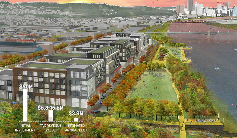
Rendering of Pittsburgh’s riverfront park space by Sasaki shows construction costs & estimates of property tax revenue & financing.
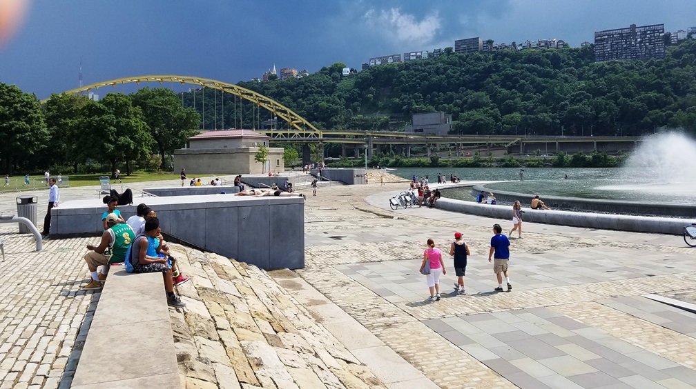
The Pittsburgh waterfront—a convergence of three rivers—has undergone an incredible transformation in recent years. This includes several major development projects from the past ten years, including the Rivers Casino, the Convention Center, and Point State Park Renovations.
Working closely with nonprofit advocacy organization Riverlife and its public and private partners, Boston-based architecture and planning firm Sasaki developed a master plan for riverfront improvements along a 20-block stretch, starting at the David L. Lawrence Convention Center at 11th Street out to the 31st Bridge, dubbed “the Strip District.”
In tandem with the design work, they also created an economic impact analysis study that focused on previous improvements, both to underscore Pittsburgh’s many waterfront successes, but also to provide an empirical basis for projecting benefits of future investment.
Approximately $130 million invested in Three Rivers Park over 15 years catalyzed nearly $2.6 billion in riverfront development activity, and nearly $4.1 billion in total riverfront and adjacent development. That’s one heck of a Return on Investment (ROI).
Cincinnati’s riverfront makeover is no less dramatic than Chicago’s or Pittsburgh’s, and its planning and design have equally been a decades-long pursuit. The downtown reach of the Ohio River was once little more than a sea of asphalt—expansive parking lots dotted with remnant infrastructure and subjected to frequent floods. A highway separated a revitalizing downtown core from the city’s former lifeblood, the Ohio River.
Opportunity was unlocked by a few key (and not insignificant) investments, one of which redesigned some badly-planned transportation infrastructure to reconnect the city to its riverfront.
Now, Cincinnati’s new Smale Riverfont Park serves as the vibrant, connective public realm. It at once knits the new riverfront district together and reconnects it with both the city’s downtown core and the river.
Featured photo by Storm Cunningham is of Pittsburgh’s Point State Park.