
For a century, the town of Arlington, Massachusetts and various local stakeholders have been exploring the feasibility and possibilities for developing a linear park along Mill Brook, an important ecological and historical feature in the town.
Now, this long-held vision might be nearing reality. On January 24, 2018. the town and the Mystic River Watershed Association held a public engagement meeting on the project. It was an opportunity for residents to learn more about the project and to share thoughts, ideas, and concerns.
 According to the project’s website, the project is “intended to serve as a model revitalization for the remaining Mill Brook Corridor — turning a hidden, underutilized waterfront into a linear park that connects people to the water and improves ecological quality’’ at the water’s edge.”
Four town-owned recreational and conservation areas are accessible along Mill Brook: Reservoir/Hurd Fields, Wellington Park, Cooke’s Hollow, and Meadowbrook Park. The brook also flows through the Town’s Mt. Pleasant Cemetery.
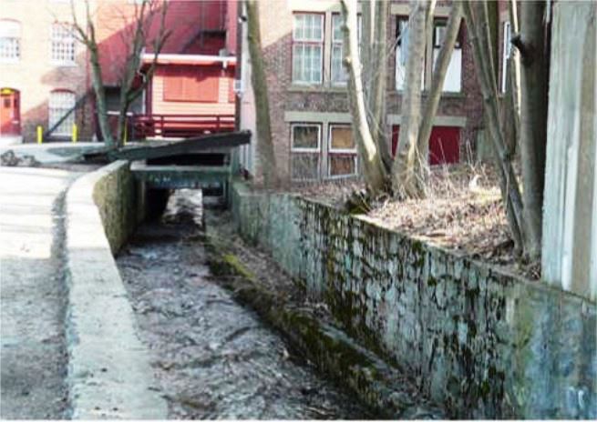
The idea is to daylight buried sections of the stream to link public greenspaces into a pedestrian-friendly greenway that connects and revitalizes the neighborhoods through which it flows. Via eclogical and landscape restoration, they hope to regenerate the environmental and visual qualities of Mill Brook, and provide enhanced recreational opportunities for Arlington’s residents.
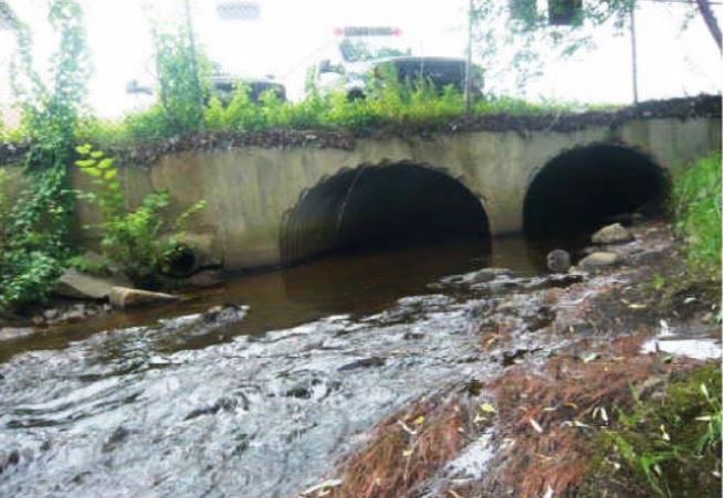
Other town-owned lands that intersect with the brook’s course—but are now culverted and thus inaccessible—include the Arlington High School property and Buzzell Field.
The Mill Brook was originally a natural waterway. The English settled in the area in 1635, and by 1637 they began the first of several man-made changes to the brook. Captain George Cooke erected the milldam near what is today’s Mystic Street, to fill his grist millpond. The first of many modifications to the Arlington section of the nearby Mystic River began in the 1650s, with the building of a causeway that served as a tidal milldam.
Mill Brook supported a series of dams and a chain of millponds from Arlington Heights to Mystic Street. There were as many as nine mills operating on the brook at one time: for grinding (e.g., grain, spices, material for drugs, paints, and dyes) and other kinds of manufacturing (e.g., wood turning, cloth printing, knives, saw blades). At one time the brook was also considered ideal for industrial waste disposal, and thus a good location for the first plant of the West Cambridge Gas Light Co. in the 1850s (in the “new” section of Mount Pleasant Cemetery).
 At one time, there were nine mills and seven millponds along the brook, which flows eastward from the Arlington Reservoir to Lower Mystic Lake. Four town-owned recreational and conservation areas are accessible along Mill Brook: Reservoir/Hurd Fields, Wellington Park, Cooke’s Hollow, and Meadowbrook Park.
When the Arlington Reservoir was built as a water supply in 1871, the reduction of water volume in Mill Brook caused many mill owners to convert to steam power, or to abandon their locations altogether. Mill Brook has been channelized, diverted, and culverted in various ways at various times over the centuries for purposes ranging from directing water flow for manufacturing use, to flood control, to the creation of playing fields. What were once the main industrial features of the map of Arlington—its broad millponds—are now some of the main recreational features of the Town.
Proposals for restoring Mill Brook and creating a park on its banks date back to the 1920s. The Town’s Comprehensive Plan of 1926 recommended a series of pocket parks along the Mill Brook. Responsive to the plan, the Town acquired the Wellington Park property (3.0 acres) in the 1930s and Cooke’s Hollow (0.7 acres) in the 1970s.
A 1977 study project for the Arlington Conservation Commission by then-Tufts University student Miriam (Mia) Guttfreund de Lehrer prepared a general plan for developing such a linear park, responsive to the pocket parks format.
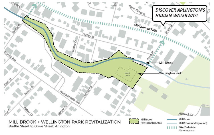
MyRWA will lead a participatory design and planning process that identifies opportunities for increasing the Brook’s visibility and new uses for the Mill Brook Corridor between Brattle Street and Grove Street, with a focus on Wellington Park. This project is intended to serve as a model revitalization for the remaining Mill Brook Corridor — turning a hidden, underutilized waterfront into a linear park that connects people to the water and improves ecological quality of the riparian edge.
The Mystic River Watershed Association’s mission is to protect and restore the Mystic River, its tributaries and watershed lands for the benefit of present and future generations and to celebrate the value, importance and great beauty of these natural resources.
All image courtesy of the Town of Arlington.