
Louisiana is known for its gumbo – a rich mixture of a variety of ingredients that combine for a dish that is known and enjoyed worldwide. Similarly, a number of groups contribute to freight movement on the Lower Mississippi River; a major supply chain artery for U. S. freight movement to and from the global marketplace that’s responsible for the movement of some 500 million tons of cargo per year.
Background:
This project won Honorable Mention in the 2018 Environmental Dredging Awards from the Western Dredging Association. It describes how a variety of stakeholders—navigation stakeholders, dredge contractors, river pilots and the U.S. Army Corps of Engineers—came together to develop a more ecologically-restorative approach to the annual channel maintenance dredging on the Mississippi River Ship Channel (MRSC).
 The idea was simply to increase the beneficial use of dredge material in the environmentally sensitive bird’s-foot delta of the Mighty Mississippi to assist the Corps’ effort to secure Coastal Zone Consistency from the Louisiana Department of Natural Resources. The focus was on finding a way to increase the beneficial use of dredged material, resulting in progress in the battle over wetlands loss in a 30-mile reach of the Mississippi River.
The beneficial use of dredged sediment on the MRSC has been instrumental in restoring habitat for a wide range of wildlife and fisheries. The wetlands created from this program provide higher elevation land ideal for nesting birds and mammals with a gentle slope towards tidal mudflats and submerged sand bars that provide excellent foraging habitat for wading birds and fisheries.
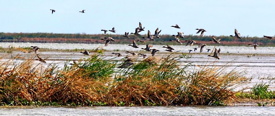
Each fall and winter this delta system is an important wintering ground for approximately one million migratory waterfowl and several hundred thousand shorebirds and wading birds. These birds flock to these newly restored wetlands for the submerged aquatic vegetation, aquatic invertebrates and other food resources these new habitats provide.
The bird’s-foot delta is positioned between the freshwaters of the Mississippi River and the deep marine high salinity waters of the Gulf of Mexico. The wetlands created by use of sediment removed from the navigation channel vary in age from 6 months to 43 years old. The first time beneficial use of dredge material was utilized in this area was in 1975 and the acreage is still there. The diverse range of maturity of habitats combined with the varying salinity regimes also provides fisheries habitat for an impressive assemblage of fisheries species.
The fringing marsh and barrier islands that have been restored provide estuarine habitat for juvenile and larval marine species while the interior fresh marsh provides habitat for many common freshwater species.
 Wetlands restored with sediment from the navigation channel of the Mississippi River Ship Channel are consistent with the goals of the 2017 Louisiana Comprehensive Master Plan for a Sustainable Coast, the North American Waterfowl Management Plan through the Gulf Coast Joint Venture Mississippi River Coastal Wetland Initiate Area, and the Louisiana Department of Wildlife and Fisheries Wildlife Management Plan.
Additionally, the restored wetlands provide habitats that benefit 49 Wildlife and Fisheries species identified as Species of Greatest Conservation Need identified in the 2015 Louisiana Wildlife Plan which include the federally listed Piping Plover and Red Knot. Many of these wetlands are located on public properties within Delta National Wildlife Refuge and Pass-a-Loutre State Wildlife Management Area which are open to public visitation and enjoyment.
Each year in excess of 30,000 public users visit these areas for hunting, fishing, camping, and nature observation. Many of the wetlands they visit are those created with dredged material from the Lower Mississippi River.
Introduction:
 The loss of wetlands in south Louisiana has been well documented and extensively studied.
Louisiana continues to experience the greatest amount of wetlands deterioration and loss of any state in the Nation; an estimated 80 percent of the Nation’s tidal wetlands loss has occurred in Louisiana, and current estimates, as much as 29 square miles are lost each year, primarily in the Mississippi River deltaic plain region of the south-central Louisiana.
The rallying cry for coastal restoration has been heard through the most famous coastal wetlands loss statement known to man, according to the United States Geological Survey: “Louisiana loses a football field of land every hour.”
With an assist from the partners identified in this award application, an exception to this trend is marsh creation and nourishment adjacent to the Mississippi River’s Southwest Pass. Over 6,800 acres of wetlands have been established and/or nourished in this area resulting from the recycling of dredged material from the Federal navigation channel maintained by the U.S. Army Corps of Engineers (USACE). An overview of the various agencies and groups that have worked together to address safe shipping, channel maintenance and marsh creation are described below.
Dredging and material placement:
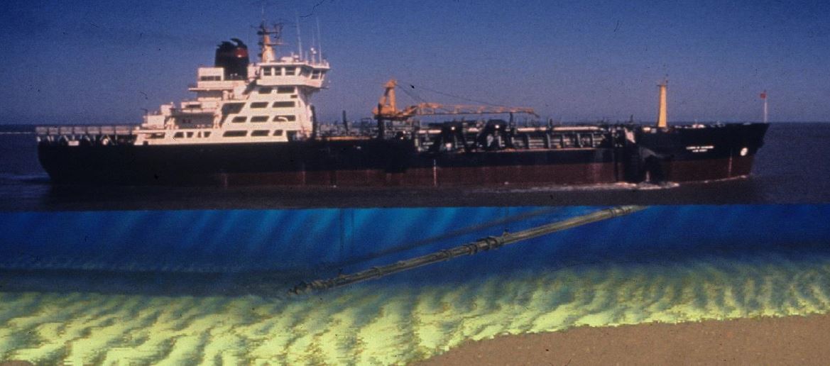
Navigation channel maintenance has historically been performed by hopper dredges, which draw sediment from the river bottom and store the material inside the dredge. When the dredges’ hoppers are full there are two ways to empty the material:
- Open the hoppers and allow the material to drop out (artist depiction below), usually after transporting the material a number of miles to an Environmental Protection Agency (EPA) approved Ocean Dredged Material Disposal Site (ODMDS) or Hopper Dredge Disposal Area (HDDA); or
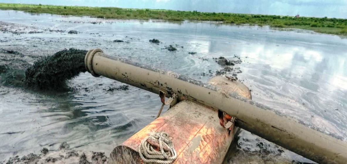
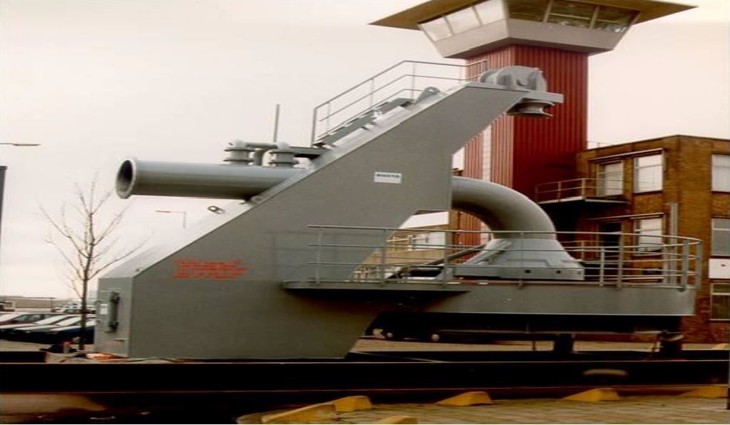
- Connect to a pump-out facility (picture) where the material can be pumped via pipeline to a placement area.
The cost of these methods varies with the distance the dredge the material has to be transported versus the time to unload the hopper. Cutterhead dredges are an alternative to hopper dredges. These dredges use pipelines to transfer the material from the navigation channel to the placement area. Unlike the mobility of hopper dredges, cutterhead dredges require anchoring spuds and cables to hold them in place and require assists from push-boats to move or clear the channel. This represents a challenge or obstacle for transiting ship traffic.
Shipping overview:
The Mississippi River Ship Channel (Baton Rouge to the Gulf of Mexico) is the busiest shipping channel in the U.S., with four of the top 11 U.S. ports located in this reach. An average of approximately 6,000 ships a year enter and depart the channel through Southwest Pass, in 2017 that number was over 7,500 ships moving 500 million tons of cargo.
The navigation channel is authorized at 45 feet deep and 750 feet wide in this reach to provide two-way traffic. Constrained Federal funding often leaves USACE unable to maintain full project dimensions (width and depth). Swift currents, frequent river bends and ship operating characteristics make safe navigation a challenge for the Bar Pilots tasked with bringing ships in and out of Southwest Pass to and from the open Gulf of Mexico. The pilotage in the extreme lower river is the responsibility of three groups – the Associated Branch Pilots, Crescent River Port Pilots’ Association and, for U.S. flagged vessels, the Federal Pilots and Docking Masters.
Federal Standard:
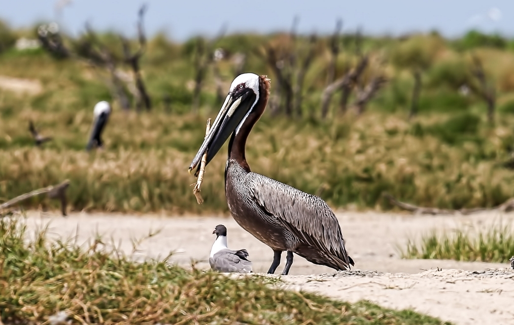
Pelican nesting on newly-created marsh in Terrebonne Parish.
The USACE seeks to beneficially use material dredged from Federal navigation channels. There are numerous examples of successful stakeholder partnering to make this happen, several of which are highlighted by USACE Regional Sediment Management Program.
That said, constrained Federal funding results in USACE having to make difficult budgetary decisions. The practice emerging has come to be called the “Federal Standard”. It can be summarized as dredged material will be placed in the least costly and environmentally acceptable manner.
Environmentally acceptable is established through the Clean Water Act (Section 401 and Section 404). In cases where a desired placement of dredged material results in additional cost, interested parties, generally through the non-Federal cost-sharing partner is responsible for funding the incremental costs.
Lower Mississippi Sediment Recycling:
Past practice for the MRSC maintenance dredging in the area of Southwest Pass was performed by hopper dredges with the material taken to an ODMDS or HDDA. This material ranges in consistency from fine silt to coarse sand. The operating manner of cutterhead pipeline dredges with swing anchors, spuds and required tug assist to move out of the channel was feared to increase the risk for safe navigation by ships. When anchored, cutterhead dredges are simply not able to move out of the way quickly especially when compared to hopper dredges or other ships.
Big River Coalition Formation:
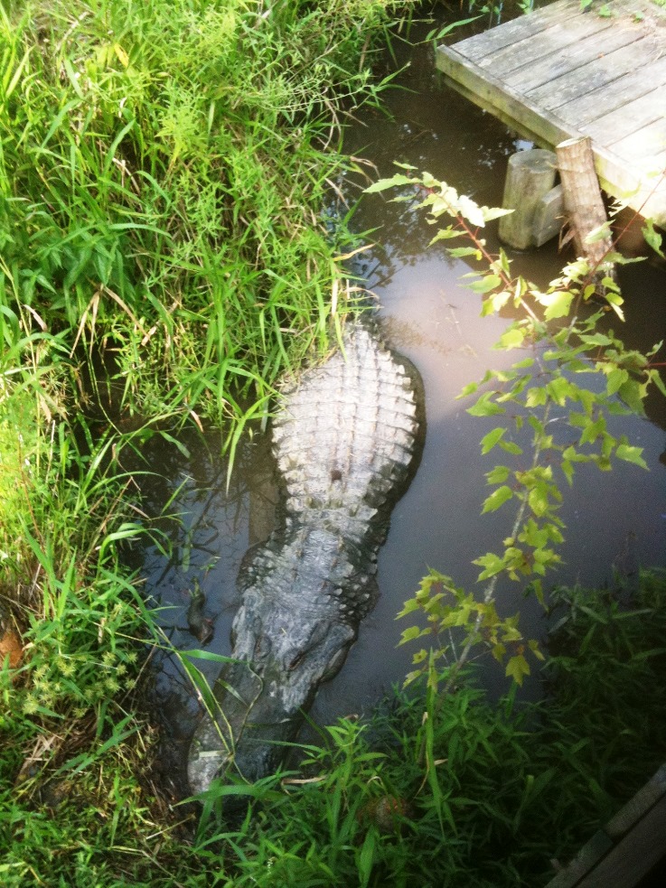
Alligator in rebuilt wetlands.
Photo by Sean Duffy.
The Big River Coalition (BRC), like many others, remembers clearly the destruction of Hurricane Katrina and adopted the rallying cry heralded across the Gulf Coast, that the region had to achieve meaningful coastal restoration in the next decade.
The process began with seeking to assist the Corps Mississippi Valley New Orleans District (MVN) in trying to increase the beneficial use of material removed by channel maintenance dredging to maintain the Federal navigation channel. The Coalition accepted the MVN challenges in maintaining the navigation channel depth and width from the perspectives of constrained Federal funding and dredge availability.
The BRC became an early supporter and vocal advocate for the Restore America’s Maritime Promise (RAMP) initiative to fully use the Harbor Maintenance Tax for its intended purpose, maintenance of Federal navigation channels.
The BRC, from its initial formation, has focused on convincing others that material removed from navigation channels are a resource to be used to benefit the environment rather than “dredge spoils” – a waste product to be disposed of. The Coalition began to use and promote the term ‘Sediment Recycling’ to highlight the benefits of placing dredged sediment along the Louisiana coast or channel edges along the bird’s-foot delta.
The BRC membership represents a broad cross section of navigation interests – deep-water and inland ports, shippers, barge and towing companies, and private companies that engage in the international trade of maritime commerce.
Corps Report on Hopper Dredge Pump-out:

Pelican taking off from new marshlands.
The MVN issued a report titled Mississippi River Southwest Pass Hopper Dredge Pump-Out Review on November 9, 2007. This report evaluated the benefits and costs of using hopper dredge pump-out facilities during Mississippi River maintenance dredging operations.
After the release of this report BRC invited other navigation stakeholders to join a new Stakeholder Group along with members of the Corps New Orleans District, dredge contractors, Louisiana Department of Wildlife and Fisheries, U.S. Fish and Wildlife Service and representatives of the Louisiana Department of Natural Resources’ Office of Coastal Management to discuss the idea of hopper dredge pump-out.
These discussions led to the formation of the Beneficial Use of Dredged Material Subcommittee. While the effort could result in beneficial use of dredged material opportunities, the cost of the pump-out equipment and pipeline as well as the cycle times of the dredge connecting to the pump-out station, emptying the hopper and returning to dredging was greater than the cost of transporting the material to the ODMDS or HDDA.
Therefore, in keeping with the Federal Standard, the Corps needed a financial commitment from the Louisiana Office of Coastal Management for the incremental cost difference over the normal dredging operations as per the Federal Standard. Corps and State discussions over the next two years did not lead to an agreement between the State and MVN on funding for the pump-out’s additional cost. The result was continued use of the ODMDS and HDDA.
Channel Maintenance by Cutterhead Dredges:
The Bar Pilots had legitimate concerns about cutterhead dredges working in Southwest Pass because cutterheads dredges are less maneuverable than hopper dredges and are anchored in place. The Corps had not used cutterhead dredges in Southwest Pass since 2002. However, in an effort to increase the beneficial use of dredged material the Bar Pilots agreed to a one-time test.
In 2009, the industry cutterhead dredge E.W. ELLEFFSEN was utilized for channel maintenance in Southwest Pass. The pilot project was successful and when the ELLEFFSEN pumped dredged material over the foreshore rocks along Southwest Pass, 46 new acres were created in Louisiana’s environmentally sensitive bird’s-foot delta of the Mississippi River. Communications between the Bar Pilots and the dredging contractors resulted in excellent coordination on dredge location and safe ship passing arrangements.
Additionally, post project completion the Pilots learned through the channel surveys that the cutterhead dredges create consistent channel dimensions and appreciated the additional buffer provided by the increased acreage. The pilots are proud of the new acreage being created each year and agree with the BRC’s view that the increased beneficial use of dredged material serves to protect or fortify the navigation channel.
Current Sediment Placement Efforts:
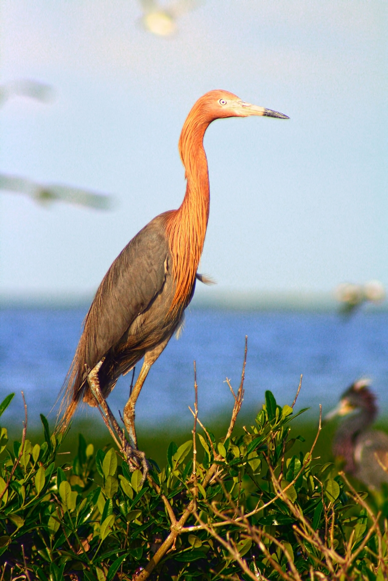
Louisiana Heron at Pass A’ Loutre.
In spite of their initial apprehension the Pilots have embraced the use of cutterhead dredges since 2009 because of their ability to provide a consistent channel while supplementing the acreage that protects the Ship Channel from open water. Navigation channel maintenance is now conducted using a combination of hopper and cutterhead dredges, working cooperatively and in tandem with each other.
The BRC used the support of the established Beneficial Use of Dredged Material Subcommittee coupled with successful stakeholder coordination with the members of the Western Regional Dredging Team to increase the maximum elevation for dredged material placement in the Mississippi River Delta. The beneficial use elevation threshold had been established as 4.5 feet Mean Low Gulf but was increased in 2015 to 4.5 feet North American Vertical Datum of 1988 a vertical increase of 3.5 feet.
This vertical datum adjustment was utilized to account for the extreme subsidence along the Mississippi River Delta, the previous target placement elevation of + 4.5 feet Mean Low Gulf was determined to be 3.5 feet lower than originally thought. This increase also allows additional quantities to be placed in areas immediately adjacent to the channel with subsequent distribution by tides and storm events.
The MVN continues to host monthly stakeholder meetings at which river flows, dredging requirements, the Operations and Maintenance budget status, and dredging plans are discussed in an open forum. This meeting is often highlighted as exemplary ‘partnering’ by dredging contractors and navigation interests in regional and national meetings.
In 2014, two cutterhead dredges were utilized for the first time in channel maintenance in the same fiscal year and this trend has continued in subsequent years. Accordingly, the number of acres created each year since 2009 has increased. In 2015 a record amount of sediment recycling was achieved with 20.9 million cubic yards creating approximately 1,000 new acres of Louisiana along the bird’s-foot delta.
In 2017 approximately 20.7 million cubic yards of material was beneficially used to create about 1,476 acres of marsh on either side of the Southwest Pass channel. These new cubic yard amounts are records for the highest amount of beneficial use ever achieved by the United States Army Corps of Engineers and the old records were directly related to dredging on the Mississippi River.
The beneficial use records prior to 2015 were achieved when the Mississippi River Ship Channel was deepened, in 1961 when the channel was deepened from 35 feet to 40 feet and then in 1987 when the channel was deepened from 40 feet to 45 feet. Since cutterhead dredges were again added to the tool box for channel maintenance and coupled with the cutterhead dredges also being used to dredge beneficial material from the Hopper Dredge Disposal Area at the Head of Pass, over 6,800 acres of new Louisiana have been created.
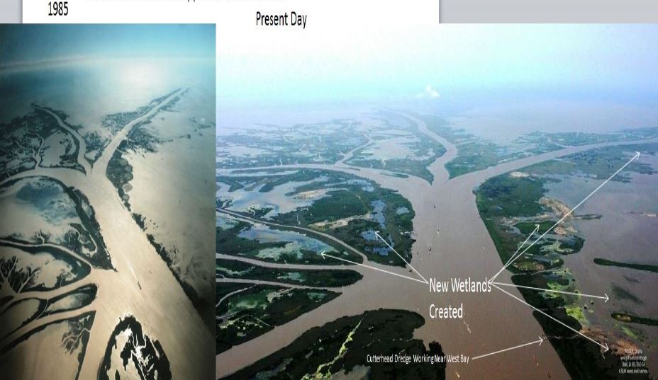
Across the Louisiana coastline there are few areas that have more land than they did 10 years ago, with the land loss attributed to sea-level rise, subsidence and even tectonic fault slippage being the common suspects. However, due to the sediment recycling program as demonstrated by the following photos there is clearly more land in this area of the Mississippi River Delta than there was 30 years ago (1985 to 2015).
The U.S. Army Corps of Engineers, Dredge Contractors, Bar Pilots, Big River Coalition have made advancements through the sediment recycling program that will prove valuable if the Mississippi River Ship Channel is deepened to 50 feet. There is no doubt that because of the additional acreage created, this critical shipping channel is better protected from storm surge than it was prior to 2009.
Environmental Impacts:
 The beneficial use of dredged sediment on the MRSC has been instrumental in restoring habitat for a wide range of wildlife and fisheries.
The wetlands created from this program provide higher elevation land ideal for nesting birds and mammals with a gentle slope towards tidal mudflats and submerged sand bars that provide excellent foraging habitat for wading birds and fisheries.
Each fall and winter this delta system is an important wintering ground for approximately one million migratory waterfowl and several hundred thousand shorebirds and wading birds. These birds flock to these newly restored wetlands for the submerged aquatic vegetation, aquatic invertebrates and other food resources these new habitats provide.
The bird’s-foot delta is positioned between the freshwaters of the Mississippi River and the deep marine high salinity waters of the Gulf of Mexico. The wetlands created by use of sediment removed from the navigation channel vary in age from 6 months to 43 years old. The first time beneficial use of dredge material was conducted in 1975 and the acreage created is still there.
The diverse range of maturity of habitats combined with the varying salinity regimes also provides fisheries habitat for an impressive assemblage of fisheries species. The fringing marsh and barrier islands that have been restored provide estuarine habitat for juvenile and larval marine species while the interior fresh marsh provides habitat for many common freshwater species.
Wetlands restored with sediment from the navigation channel of the Mississippi River Ship Channel are consistent with the goals of the 2017 Louisiana Comprehensive Master Plan for a Sustainable Coast, the North American Waterfowl Management Plan through the Gulf Coast Joint Venture Mississippi River Coastal Wetland Initiate Area, and the Louisiana Department of Wildlife and Fisheries Wildlife Management Plan.
Additionally the restored wetlands provide habitats that benefit 49 Wildlife and Fisheries species identified as Species of Greatest Conservation Need identified in the 2015 Louisiana Wildlife Plan which include the federally listed Piping Plover and Red Knot. Many of these wetlands are located on public properties within Delta National Wildlife Refuge and Pass-a-Loutre State Wildlife Management Area which are open to public visitation and enjoyment.
Each year in excess of 30,000 public users visit these areas for hunting, fishing, camping, and nature observation. Many of the wetlands they visit are those created with dredged material from the Lower Mississippi River.
Thanks to the many organizations and individuals contributing to this Feature Article for REVITALIZATION:
- Big River Coalition (Sean Duffy, who won The American Shore & Beach Preservation Association’s Coastal Innovator Award in 2016 as a result of this project)
- American Association of Port Authorities (Jim Walker)
- Associated Branch Pilots of the Port of New Orleans (Captain Michael Miller)
- Crescent River Port Pilots Association (Captain Michael Bopp)
- Federal Pilots and Docking Masters of Louisiana (Captain Greg Bush)
- Great Lakes Dredge & Dock (Steve Auernhamer and Bill Hanson)
- Manson Construction (Henry Schorr)
- Louisiana Department of Natural Resources (Greg Ducote and Jeff Harris)
- National Oceanic and Atmospheric Administration (Tim Osborn)
- Weeks Marine (Chuck Broussard)
- United States Army Corps of Engineers (Ed Creef, Michelle Kornick and Joaquin Mujica) and
- United States Fish and Wildlife Service (Barret Fortier and James Harris)
Featured photo of pintails and blue winged teal ducks over New Louisiana is by P.J. Hahn.