
Over the past two decades, numerous communities across the United States have used river restoration projects to reclaim neglected waterways, spur economic revitalization and stoke community pride. There’s no shortage of opportunities: tens of thousands of dams are busy killing rivers nationwide.
The vast majority of them are obsolete, silted beyond functional value, or never had a good reason to be built in the first place. The U.S. Army Corps of Engineers operated on a “use it or lose it” budgeting process: they had to spend all of their money, or the next year’s budget would be reduced by the unused amount. Thousands of useless dams were built as a result, inflicting billions of dollars of damage on the nation’s recreational and commercial fisheries.
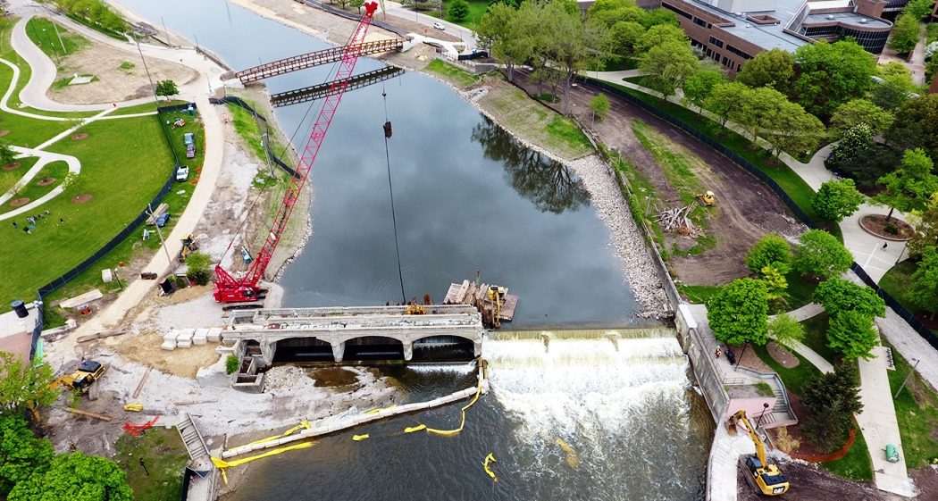
Hamilton Dam in 2016.
Photo courtesy of the State of Michigan.
Now it is Flint, Michigan’s turn to enjoy the economic and environmental benefits of removing their Fabri and Hamilton dams. Water is now flowing through openings during demolition of the Hamilton Dam, which has been underway for about 10 weeks. “The Fabri Dam has been removed, and the contractors are just finishing up at the Hamilton Dam right now,” says Janet Van De Winkle, Genesee County Parks and Recreation project manager said.
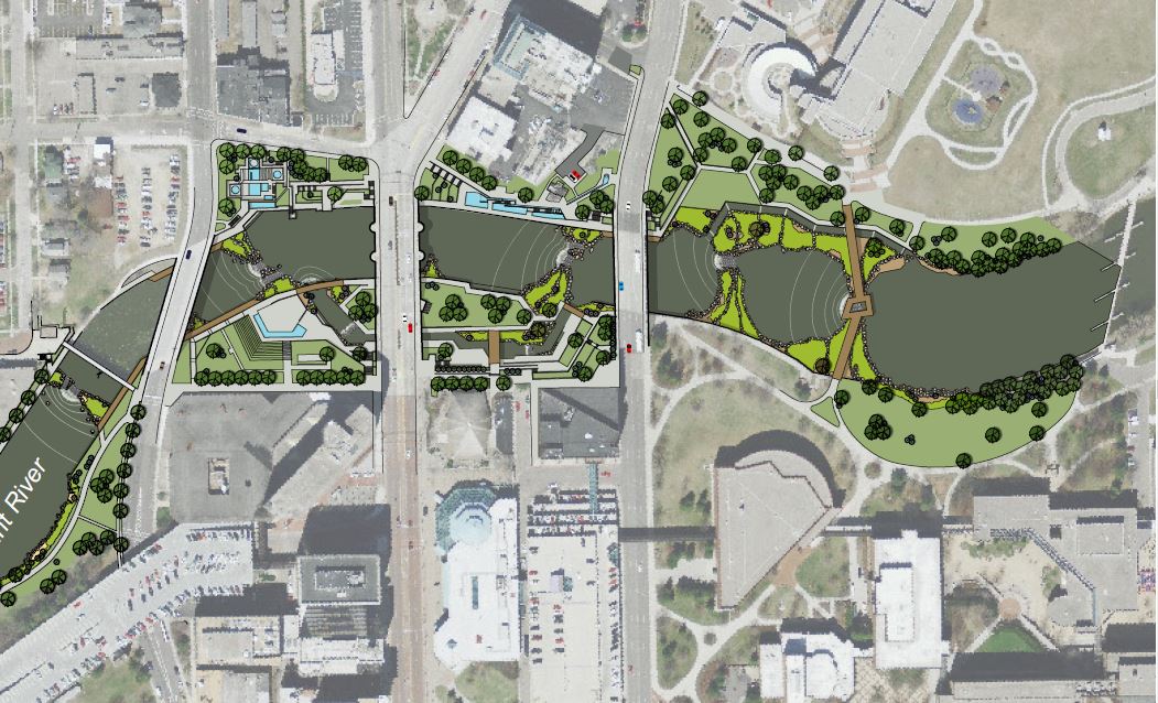
The removal of the Hamilton Dam was the beginning of a huge project that will transform a nearly two-mile stretch of the Flint River that flows through downtown Flint. The Flint River Restoration Project, which could cost up to $38 million, will convert a largely inaccessible stretch of the river into a safer, more natural waterway — one that is welcoming to anglers, paddlers and people who enjoy the sights and sounds of flowing water.
“Everything above the water was falling apart and was taken down. The function of that dam wasn’t really there anymore. They left the substructure, the part underwater, and the in-stream restoration will begin constructing a series of pools and drops, so you can safely kayak up and down that stretch of the river,” said Rebecca Fedewa, executive director of the Flint River Watershed Coalition.
 Naturalizing the stretch of river that snakes through downtown Flint will transform a concrete wasteland into a usable public space that is aesthetically pleasing. It also will complement the rest of the 142-mile long Flint River, parts of which are as remote and scenic as rivers in northern Michigan.
Community leaders and government officials who worked for more than a decade to create a new vision for the city’s waterfront said the project will improve water quality, provide fish passage and create new recreational opportunities. The two-year project will improve the most degraded section of the river and fundamentally alter how people interact with it, said Amy McMillan, former director of the Genesee County Parks & Recreation Commission.
The Flint Riverfront Restoration Project provides a vision that will transform a neglected resource into a vibrant community asset. That vision calls for the rejuvenation of both the river and riverfront through the creation of water-based recreational opportunities, park improvements, redevelopment of underutilized properties, enhanced community connectivity, ecosystem restoration and improved stormwater/flood control.
Downtown Flint riverfront.
Photo via Adobe Stock.
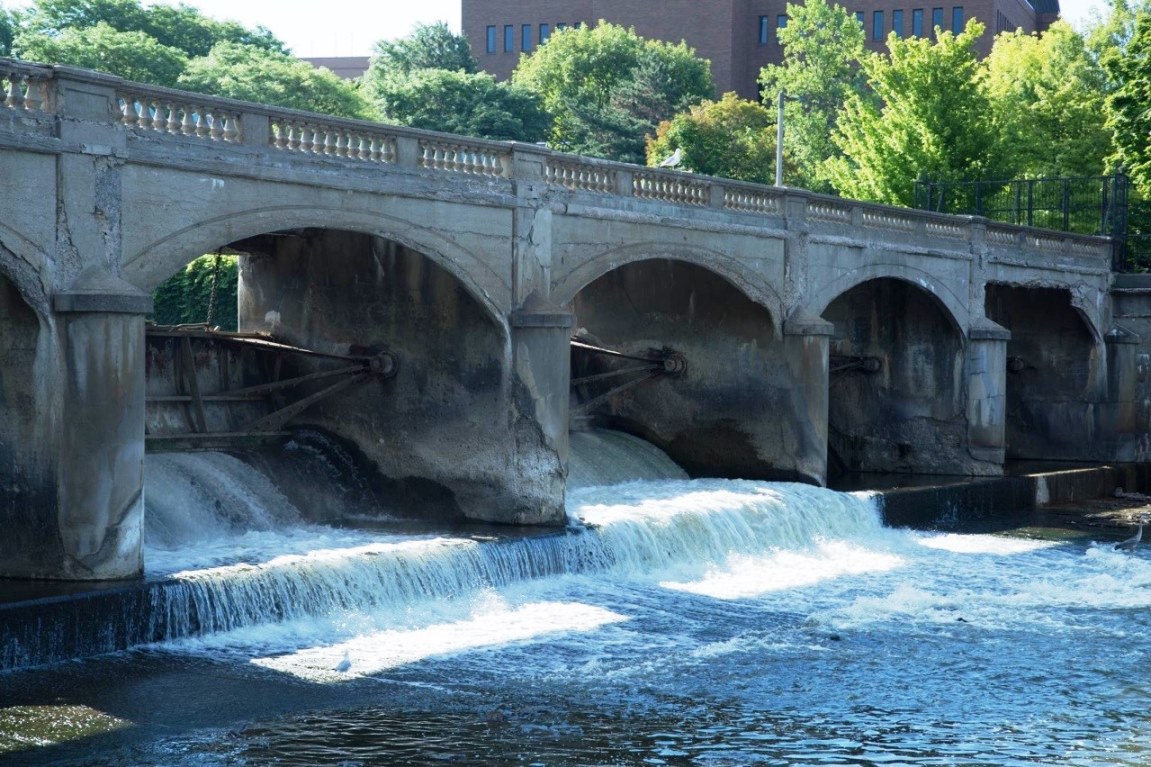
The key driver for the development of the Flint River Restoration Project is the need to improve the Hamilton Dam, located along the Flint River in the heart of downtown (near the University of Michigan-Flint campus). The City of Flint and other stakeholder organizations have been evaluating potential improvements to the Hamilton Dam for several years.
The Hamilton Dam has a long history of service to the City of Flint. Constructed in 1920, it facilitated milling operations for the region’s logging industry and served as a water source for local industries. Throughout its life, the dam has helped regulate the flow of water in the Flint River. In the 1960’s, the dam served as the upstream anchor point for the U.S. Army Corps of Engineers’ Flood Control Project.
In late 2009, the City of Flint engaged a team of consultants to develop a preliminary design for modifications to the Hamilton Dam, building upon past studies of the riverfront area. Seeing an opportunity to establish a strategy for change across an area well beyond the Hamilton Dam itself, the city also directed the consultant team to develop a restoration plan encompassing the larger Flint Riverfront within downtown Flint. Over the course of an approximately one year planning process, this Flint Riverfront Restoration Plan was established.
The Flint Riverfront Restoration Plan builds upon multiple engineering, design and planning studies related to the Hamilton Dam and Flint Riverfront. The Flint Riverfront Restoration Plan and companion technical reports provide the data needed to move forward with the development of detailed construction documents to implement the recommended modifications.
As part of the overall effort, the following tasks were completed:
- Community engagement meetings;
- Topographic and bathymetric survey and base plan development;
- Hamilton Dam condition assessment;
- Hydraulic modeling of the river corridor and associated coordination with state and federal regulatory agencies;
- River bottom sediment testing and analysis;
- Fish passage assessment;
- Existing condition assessment of the riverfront and assembling of past planning and design studies;
- Design recommendations for the dam and riverfront;
- Permitting coordination; and
- Cost estimates, construction sequencing and funding analysis.
“People who are resource-minded are very excited about this project,” said Joseph Leonardi, a Michigan Department of Natural Resources fishery biologist who has studied the river for more than two decades. “I think there is a strong sense that making the river a focal point in the community will be good for Flint.”
Highlights of the project include:
- Removing the Hamilton and Fabri dams, which will eliminate the last manmade barriers in the river between Flint and the Shiawassee National Wildlife Refuge in Saginaw. The Flint River is a major tributary in the Saginaw River system, which connects to Lake Huron’s Saginaw Bay and its thriving walleye fishery;
- Scattering large boulders in a section of the river in downtown Flint. The boulders will create rapids that emulate the natural shape and flow of the river, improve water quality, and create better opportunities for kayaking and canoeing. Rock terraces and vegetation also will be added to parts of the concrete channel, to provide seating and create a more natural look;
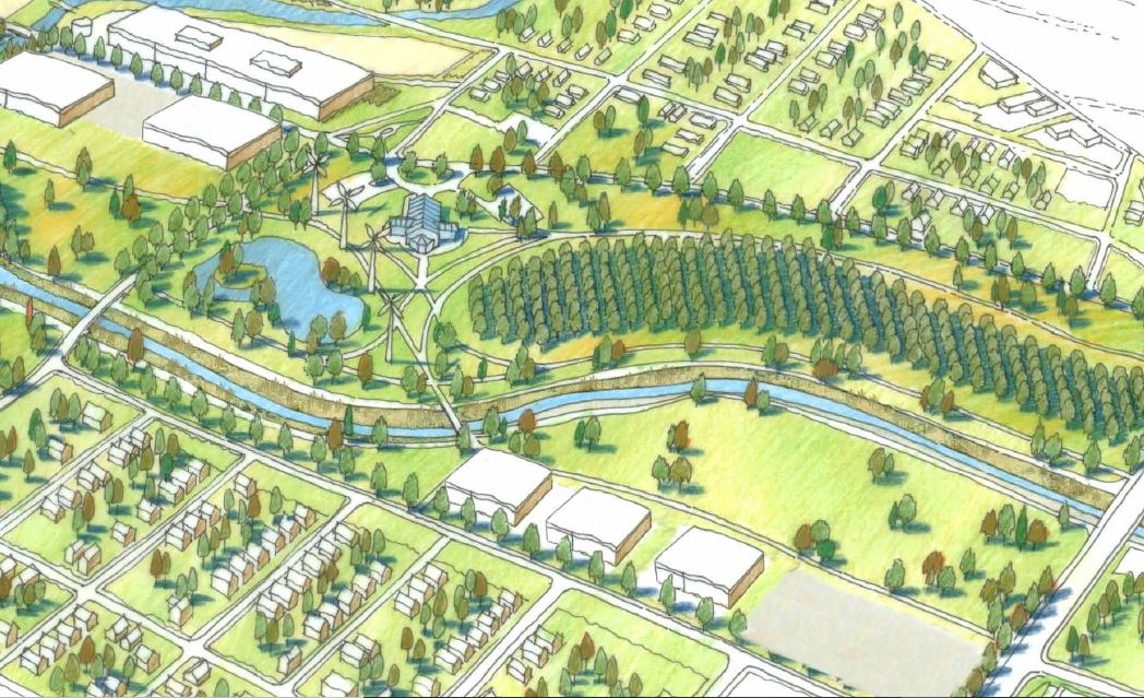
- Completing Chevy Commons, a 60-acre park that once housed a General Motors manufacturing facility. It will feature walking trails, play areas, a bike path and a footbridge linking Chevy Commons to Carriage Town, near Kettering University; and
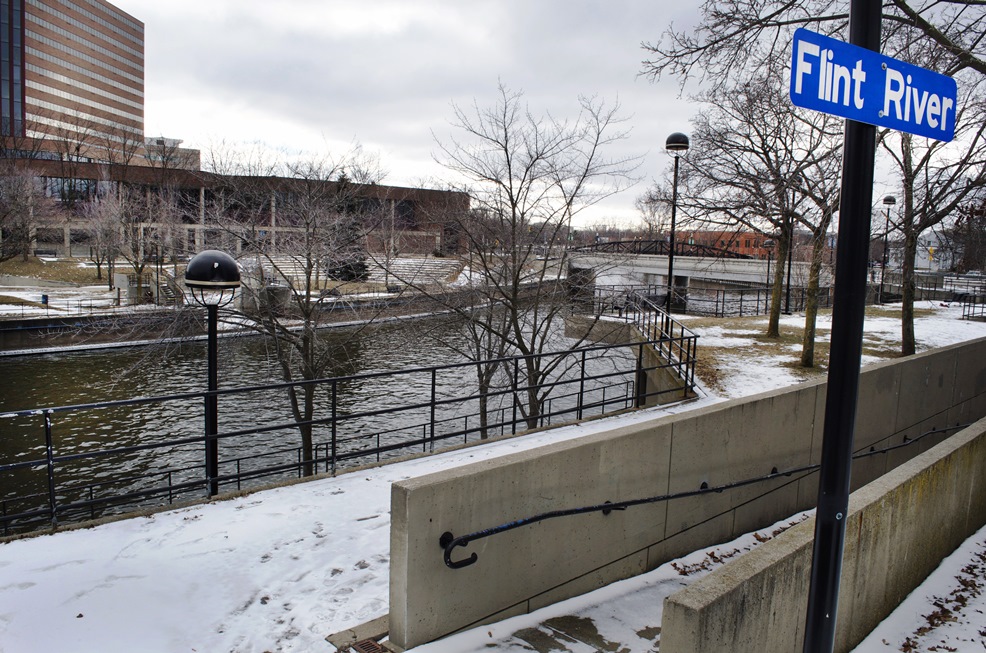
- Renovating Riverbank Park and adding bike/pedestrian paths. The linear park will be overhauled to improve physical and visual access to the river, add a kayak launch and redevelop the existing amphitheater. New bike paths will connect downtown Flint to Kettering University, Chevy Commons and surrounding neighborhoods. Those trails also will connect Flint to the state’s Iron Belle Trail, which will link Detroit’s Belle Isle to the city of Ironwood, in the Upper Peninsula.
“It’s so exciting to contemplate a new era of people safely fishing along the river or heading down the river in a canoe or kayak,” added Fedewa. “This project will help build a connection that Flint residents haven’t had with the river, because it wasn’t accessible.”
 The Flint Riverfront Restoration Plan provides a vision that will transform the Flint Riverfront from a neglected resource into a healthy and vibrant community asset. The vision calls for the rejuvenation of the river and riverfront through the creation of water-based recreational opportunities, park improvements, underutilized property redevelopment, enhanced community connectivity, ecosystem restoration, and improved stormwater/flood control. The key driver of the Flint River Restoration Plan is addressing the Hamilton Dam, which is located in the heart of downtown, near the University of Michigan-Flint campus.
The $3 million dam removal project was funded by the Michigan Department of Natural Resources‘s Dam Management Grant Program, which is addressing the problematic dams challenge throughout Michigan.
There are almost 2600 dams in Michigan. Many are small and privately owned. And nearly all are old. According to a 2014 report, 90% of Michigan’s dams will meet or exceed their design life—the length of time for which they were designed to operate—by 2020. Beyond that point, they are increasingly likely to fail. That can lead to catastrophic flooding, erosion, and the spread of toxins trapped behind the dam.
That likely spells hundreds of immediate community revitalization opportunities in a state that can use all it can get. All eyes are on Flint, which is helping to lead the way, and which could use revitalization more than just about any other city in America
Featured photo by Mayberry Media via the Charles Stewart Mott Foundation. All renderings are from the Flint River Restoration Plan.
See June 12, 2018 MLive article by Zoe Jackson.
See Charles Stewart Mott Foundation article.
See Flint River Restoration Project website.