

A guest article for REVITALIZATION by Tracy Strickland and Tamim Younos.
Twenty-first century America is approaching a turning point in its approach to urban stormwater management. The 20th century engineering that made rapid land development possible is now failing and creating a host of problems. Cracked and collapsing pipes causes major urban floods as undersized culverts fail to handle the stormwater runoff generated due to extensive amounts of impervious surface area. The health of many streams is severely degraded; their inherent functions of nurturing life, transporting material and containing flood waters are disconnected from surrounding natural systems.
Further exacerbating this situation is the fact that many municipalities continue to replace the underground infrastructure system. The act of placing or keeping natural water systems in underground pipes to facilitate land development remains a common practice. Fortunately, current trends in environmental awareness and stewardship are making it possible to imagine and build more sustainable futures for U.S. cities and their invisible rivers, streams, and creeks. Movements toward “green infrastructure”, Low Impact Development (LID), and environmental Best Management Practices (BMPs) are gaining ground in public debate, policy making, and land planning and design.
Urban stream daylighting, i.e., removing streams from underground pipes, is emerging as a viable and multifaceted tool in the green infrastructure arsenal. Stream daylighting is a biological engineering technology that allows for some degree of restoration of vital stream functions. It also provides meaningful and valuable public greenspace space in urban environments, and presents an innovative long-term land use planning tool that permits existing stream systems to evolve simultaneously with their surrounding built contexts. The future character of many urban and suburban neighborhoods can be linked to their historic streams, thus stream daylighting can become an integral part of planning the future of both natural and human systems.
Daylighting is a deliberately willful act. It seeks to render visible that which is currently invisible by intentionally disrupting the neat patterns of pavement that characterize modern U.S. settlements. It replaces missing pieces of a living system that are easily ignored because they are officially ‘out of the way’, beneath our feet, and contained safely in a concrete box or pipe. It also endeavors to restore a crucial missing link in the human psyche by restoring water to its rightful place as an essential life-giving force. Revealing buried waterways through stream daylighting is a catalyst not only for design, but for reconnecting ourselves to our place in nature [1].
This article presents challenges and opportunities that urban stream daylighting can offer a community wishing to restore a buried stream to visibility and vitality. Two case studies of stream daylighting projects are examined.
Urban Stream Daylighting – The Concept
The word itself – ‘daylighting’ – is often unfamiliar to most people, who confuse it with bringing daylight into the interior of a room or building. “The term describes projects that deliberately expose some or all of the flow of a previously covered river, creek, or stormwater drainage” [2]. Daylighting projects usually remove a stream from an underground pipe and restore the waterway to open air. It is sometimes referred to as an urban stormwater Best Management Practice (BMP) retrofit, because it is a practice usually accomplished in physical surroundings substantially altered by the built environment.
In 1984, the first “official” daylighting project occurred along a section of Strawberry Creek in a park in Berkeley, California, and is widely considered the archetype of daylighting [2]. Since then daylighting projects have steadily increased across the country. Measurable benefits of stream daylighting include improved riparian habitat and water quality along newly created stream banks; reduced flood impacts by increasing storage capacity in comparison with underground culverts; and reduced urban “heat island effect.”
Daylighted streams can increase property values and business investment opportunities in stream redevelopment zones, add intrinsically valuable public open space to dense urban communities and consequently enhance aesthetic environment. Many communities are finding that the costs associated with ‘daylighting’ a stream can be less than designing new pipes and re-burying the stream [3].
Daylighting Approach and Outcomes
Urban stream daylighting site selection and design procedures are described in [4]. In urban stream daylighting, the physical constraints of a given location yield three common stream design outcomes – artificial streams, channelized streams and naturalized streams (Fig. 1).
Artificial streams are usually accomplished in highly built urban environment where little space is available for a meandering, shaded stream bed. The resulting daylighted stream needs to be rigidly controlled on all sides, most likely in a lined concrete channel between buildings. This is akin to urban drainage and the new stream resembles the hard control found in bedrock and cascade channels. An ‘artificial stream’ has little ecological function except to contain and control water flow. It is sometimes referred to as “cultural restoration” because it highlights the water’s path without restoring the stream’s basic functions.
Channelized streams are typically found in a suburban setting or urban area with large vacant parcels. The new stream will likely require stream bank stabilization and some grade controls to prevent erosion and bed incision. The physical setting results in stream designs resembling step-pool, plane bed, and pool-riffle streams, and accommodate some in-stream features like cross-vanes along with riparian vegetation. Channelized or ‘architectural’ streams offer a higher degree of ecological function than artificial streams — the channel is restored to open air and flowing water, and some aquatic habitat added while still in a partially constrained channel.
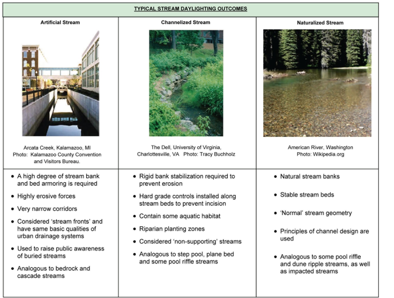
Fig. 1Typical stream daylighting outcomes (image credit as noted under each)
Naturalized streams are typically completed in rural settings or on large pieces of property such as school fields and campuses; greater land area exists to re-establish floodplains, wetlands and ponds, sinuous natural stream banks, and wider stretches of riparian plantings and forest buffers. Naturalized streams closely resemble pool-riffle and dune-ripple stream systems and offer the highest degree of ecological function and typically see the largest number of returning fish and insect species within their channels.
In this article, two unique case studies of recent urban stream daylighting projects are described (Table 1). More case studies can be found in [4].
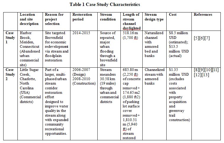
Table 1: Case Study Characteristics
Case Study 1 – Harbor Brook Redevelopment Site, Meriden, Connecticut
Background Information
The City of Meriden, Connecticut (USA) is home to the Harbor Brook sub-watershed region, which covers 31.86 km2 (12.3 mi2), approx. 50% of Meriden’s total land area. The center of the city sits at a topographical low point ringed by basalt ridges. Through these ridges runs Harbor Brook, winding its way through the heart of the city, including an abandoned industrial site called “The HUB” (Fig. 2). Within the site, Harbor Brook runs 5.6 km (3.5 mi) between Baldwin and Hanover Ponds, ultimately draining into the Quinnipiac River [5].
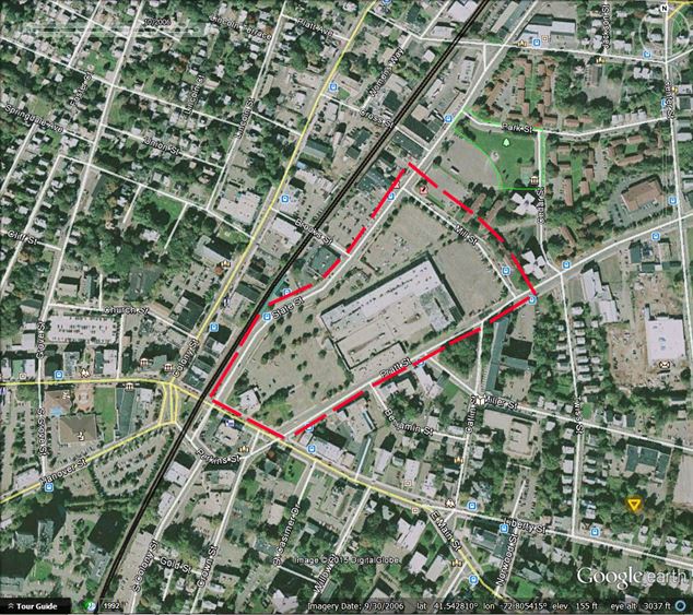
Fig. 2 Harbor Brook Redevelopment Site, Meriden, Connecticut. (Source: Sanborn 2006, as displayed in Google Earth™).
“The site was initially developed as a manufacturing zone to take advantage of the nearby rail line and Harbor Brook as a power source…[the site] historically served as a center of industrial and commercial activity in Meriden’s downtown” [5]. As a result, over 300 residential and commercial properties sat within the existing Harbor Brook FEMA-approved 100-year floodplain, equating to roughly 91.05 hectare (225 acres) [5].
History of Harbor Brook and the Harbor Brook Flood Control Plan
Over time, the relationship between Harbor Brook and the downtown site became detrimental to both. “At least eleven major flooding incidents since the late 1860s have caused substantial economic damage in Meriden’s central city. In 1992 and 1996, major floods – caused in part by an Amtrak bridge south of the downtown business district that was undersized and sitting at a very low profile to Harbor Brook – cost the city an accumulated $26 million (USD) worth of property damage. In 1992, further financial loss occurred when a flood caused a major employer (more than 300 employees) to relocate outside downtown “[6].
As a result of these significant flooding problems, the city developed and began to implement the Harbor Brook Flood Control Plan. It is a comprehensive set of flood control measures along Harbor Brook, with the dual-purpose of alleviating historic flooding problems and providing a new economic development zone adjacent to their new TOD (Transit Oriented District) [5].
Key flood control components in the plan are:
- Floodwater Detention Areas – the site is expected to provide 21.45 hectare (53 acres) of stormwater storage
- Harbor Brook channel improvements – widening and deepening the existing channel to improve overall hydraulic capacity, and realigning the channel to take fuller advantage of the site acreage
- Continued replacement and removal of hydraulically inadequate bridges along Harbor Brook from Center Street to Hanover Pond
- Construction of retention/detention ponds on the east side of the City (to slow down flood waters prior to reaching the HUB site)
- Daylighting Harbor Brook
Daylighting Project Details
The daylighting portion of the project involved removing twin, concrete box culverts to expose the existing stream channel. Each box culvert was 2.13 m x 4.57 m (7 ft x 15 ft) – basically a 9.14 meter (30 feet) wide underground channel. The new stream corridor is designed to be a low flow channel sitting at one elevation, which will handle a typical 2-year storm event. The bottom of the channel is reinforced with heavy duty stone; the stream banks are similarly armored with varying sizes of boulders all the way to the top of each slope, where the material transitions to vegetation [7].
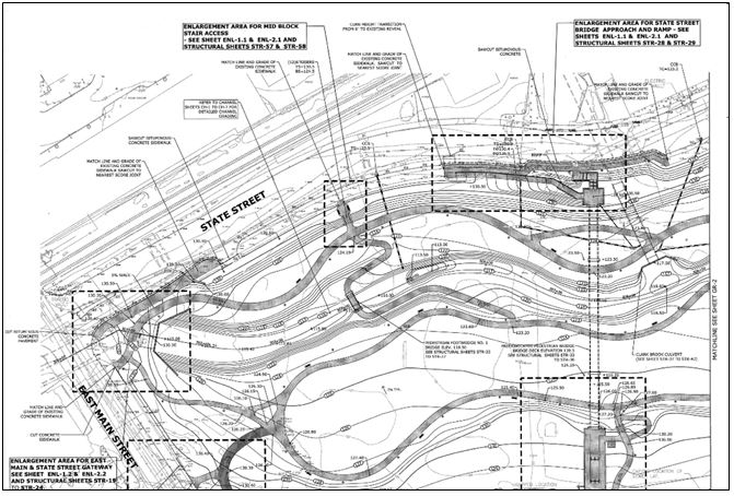
Fig. 3 Harbor Brook stream daylighting grading and site plan. Site design and plan graphics by Milone & MacBroom, Inc. Cheshire, Connecticut (USA), July 31, 2013 (Image courtesy of Robert Bass, P.E., Director, Department of Public Works/Engineering Division, Meriden, CT.
Harbor Brook is not the only underground stream getting daylighted with this project: adjacent Jordan Brook was also removed from about 18.29 meters (60 feet) of concrete culvert, and nearby Clark Brook was slightly daylighted and rerouted around an existing bridge pier. Both tributaries will converge with Harbor Brook on the 5.83 hectare (14.4 acre) public park site, which has now been re-graded and designed to withstand floodwaters from a 100-year storm event (Fig. 3) [7].
Construction by LaRosa Construction, Inc. began with initial building demolition and the removal of hazardous material. During that process, special scaffolding had to be placed over culverted sections of Harbor Brook to catch falling building material that was itself contaminated with asbestos. City engineers did not want any harmful chemicals entering the stream channel, so this method was employed as a preventive measure. In spite of that, the project is well on track to meet its contracted completion date of December 31, 2015 [7].
“The City’s Capital Improvement Program calls for the completion of $22.15 million (USD) in flood control project components over the next five years (2014-2018)” [5]. in addition to the HUB site development costs. According to Robert Bass, P.E., Director of the Public Works Department for the City, the final project expenditures came close to costing nearly twice the initial estimates due to previously unknown underground hazardous materials that the City removed and properly disposed of. A 5.30 m3 (1,400 gallon) oil storage tank, with product still contained inside, was discovered during excavation, which required removal, disposal and soil mitigation in order for construction to move forward [7].
Outcome
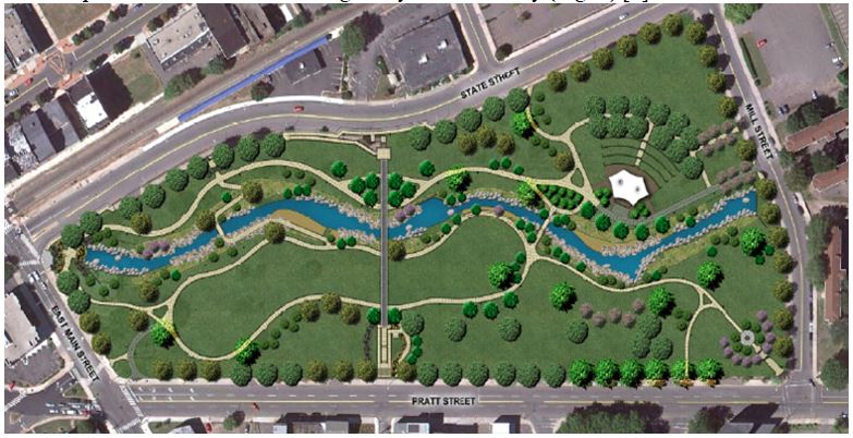
Fig. 4 Harbor Brook stream daylighting and HUB redevelopment site. Site design and plan graphics by Milone & MacBroom, Inc. Cheshire, Connecticut (USA) (Source: Westport CT Master Plan, 2013
The redevelopment of the site – including daylighting Harbor Brook – will store flood waters in certain storm conditions to prevent flooding in the immediate downtown area. It will also provide ample outdoor space for a large amphitheater and great lawn for public events. This central green space will be combined with a linear trail system right alongside the Harbor Brook channel to provide a recreation link diagonally across the city (Fig. 4) [5].
Additionally, 227 properties will be removed wholly or partially from the 100-year floodplain, opening up the project site to 139,354 m2 (1.5 million ft2) of new development area “without the risk of economic damage from future flood events” [10, p 4]. The overall acreage within the 100-year floodplain will be reduced from 91.05 hectare to 38.45 hectare (225 to 95 acres) [5].
In addition to controlling flood waters and creating a much-needed centralized park, one particular outcome of the daylighting and flood control project is especially gratifying for the city — it is generating a high level of economic interest among business developers keen to move into the heart of the downtown business district. The interest is so high, that it has unexpectedly shifted priorities away from bridge replacement to stream daylighting. Site construction will be completed in less than one year, and the stream channel has been widened and deepened to remove the entire park from the 100-year floodplain. As a result, Bass says “Bridges come second now.” [7].
The revitalization of Harbor Brook comes first, as it has become a catalyst for the rapid revitalization of economic investment in downtown Meriden.
Case Study 2 – Little Sugar Creek, Charlotte, North Carolina
Background Information
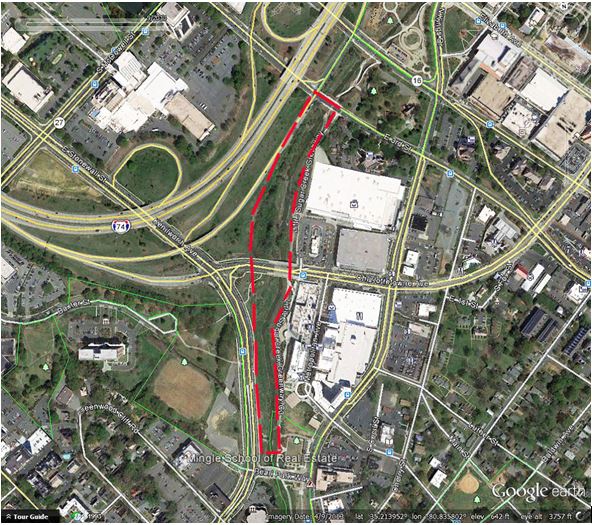
Fig. 5 Little Sugar Creek, Kings Drive reach, Charlotte, North Carolina (USA) (Source:Unknown 2013, as displayed in Google Earth™). History of Little Sugar Creek
Little Sugar Creek and its major tributary, Briar Creek, drain 132.09 km2 (51 mi2) in and around Charlotte, North Carolina (USA). Little Sugar Creek travels through Mecklenburg County, North Carolina – beginning just west of a ridge that divides the Catawba River watershed from the Yadkin-Pee Dee watershed. Little Sugar Creek continues south through Mecklenburg County to join Sugar Creek which continues to the Catawba River east of Rock Hill, South Carolina (USA). “The Little Sugar Creek watershed is located in a highly developed urban setting; approximately 80% of the land in the watershed has been developed. Approximately 43% of the land surface is impervious. The land uses within the watershed include residential (47%), industrial (25%), commercial (19%), woods (7%), and institutional (2%)” (Fig. 5) [8].
Little Sugar Creek was rendered vulnerable to countless problems caused by poor treatment from residents, businesses and governments. From the time of the city’s founding in the 1760s, residents and businesses took full advantage of nearby streams as places for dumping raw sewage from outhouses and then apartments, as well as industrial waste and chemicals like gas and chlorine [9].
As suburban America boomed after World War II, downtown Charlotte expanded. On October 28, 1959, almost 50,000 people turned out for the grand opening of the Charlottetown Mall (aka Midtown Mall), the Southeastern United States’ first enclosed shopping mall. The mall’s concrete parking lot was built on top of Little Sugar Creek. “Nearby businesses wanting parking space did the same thing, putting Little Sugar Creek in the dark for more than 40 years” [9]. Over the course of modern history much of the creek had been altered to accommodate development.
In a report prepared by Buck Engineering in 2006 for the City of Charlotte, “The creek has historically been dredged and maintained as a flood control channel. Most of the banks have been armored to prevent erosion from high flow velocities. The creek has been capped to accommodate commercial use: the Midtown Square parking cap extends for (32.61 m) 170 LF just upstream of Morehead Street. The former McDonald’s cap extends for (208.79m) 685 LF through the middle of the project reach. The former Bank of America parking cap extends for (64 m) 210 LF near the upstream portion of the project.” [8]
Daylighting Project Details
As part of the effort to improve water quality and flood control the along highly urbanized stream in downtown Charlotte, the city implemented a prominent segment of a $42 million (USD) project called the Little Sugar Creek Greenway. The project had two main goals: to create a trail to serve as a destination for tourism and recreation and to improve water quality [10]. Some of this was achieved by adding natural meanders, pools and riffles, rain gardens and natural/native plantings along the banks of the creek.
Design plans were prepared to uncover Little Sugar Creek and install natural channel designs meant to improve water quality and re-create the natural conditions of the creek. The project was broken into several phases that reflected different stream reaches along its urban corridor. The entire [daylighting] project was from 7th Street to Morehead Street. The bulk of the uncapping occurred in the reaches called Kings Drive and Midtown [11]. The drainage area at this point in the watershed is 17.14 km (10.65 miles) [12].
The Kings Drive reach “was almost 100% capped with concrete lined banks and concrete cover (Fig. 6). This reach was stable due to the concrete lined channel, however, there was no buffer and the water quality and habitat were very poor in this reach. The goal for this reach was to uncap [sections of] the channel and construct a new channel and floodplain bench. It would also include riffle and pool bedform features using boulder structures to improve water quality and provide vegetative buffers for habitat and stability” [12].
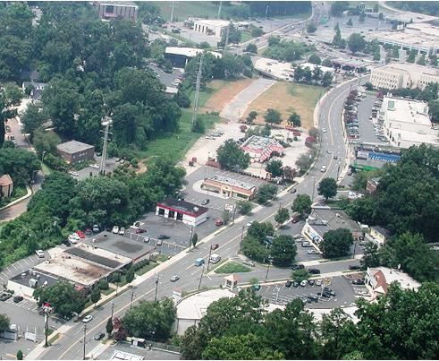
Fig. 6 Little Sugar Creek prior to construction, Meredith Moore, Mecklenburg County Storm Water Services. (Image courtesy of Crystal Taylor, P.E., Charlotte-Mecklenburg Storm Water Services, 2002)
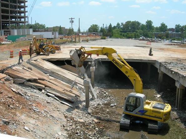
Fig. 7 Former Midtown Mall parking deck during demolition, Jay Higginbotham, Mecklenburg County Asset and Facility Management. (Image courtesy of Crystal Taylor, P.E., Charlotte-Mecklenburg Storm Water Services, 2007)
Approximately 685.8 m (2,250 ft) of covered stream were daylighted from Midtown Square along Kings Drive to Morehead Street. 174.66 m2 (1,880 ft2) of parking lot coverage was removed (Fig. 7) [12]. To improve aquatic habitat, “Boulder cross vanes and riffles were installed to improve the fish and macroinvertebrate habitat in the stream by providing the riffle and pool sequences that a healthy stream requires. The cross vanes will also protect the stream bank from erosion while lowering the stress on the stream banks during storms” (Fig.8) [12].
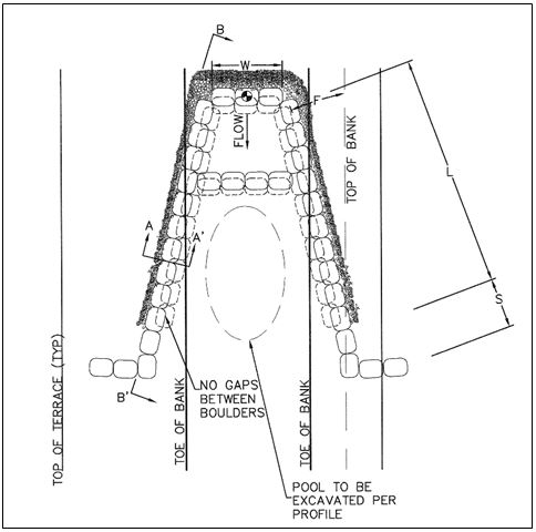
Fig. 8 Little Sugar Creek cross vane detail, Michael Baker Engineering, Inc. Charlotte, North Carolina (USA), May 12, 2009 (Image courtesy of Crystal Taylor, P.E., Charlotte-Mecklenburg Storm Water Services)
As part of the project, the Charlotte-Mecklenburg Utility Department planned to install a 60 inch relief sewer which enabled the sewer line to relocated from the left bank of the stream to the right bank closer to Kenilworth Avenue. This allowed the stream restoration project to construct a large floodplain bench on the right bank and meander the creek away from the left bank into the left floodplain area” (Fig. 9) [12].
According to Crystal Taylor, P.E., of Charlotte-Mecklenburg Storm Water Services Department, “The low flow bankfull channel was designed for the 28.31 cubic meter/second (1,000 cubic feet/second) event which is between the 1- to 2-year event. Because of the urban nature of the project and the constraints (power transmission lines, 1-277 ROW, sewer lines, etc.) we could not add true geomorphic energy reducing meanders. We added in meanders where we could, but they are more aesthetic meanders” [11]. To implement the greenway-specific part of the project, plans required a 30.48-meter (100-foot) riparian buffer and buyouts of flood-prone properties which then facilitated constructing 1,931.21 m (6,336 ft) of greenway trail and one pedestrian bridge that connects Kings Drive to Harding Place [12].
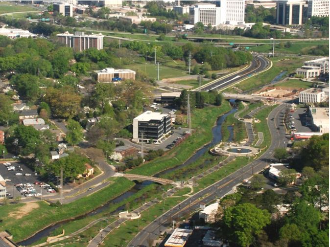
Fig. 9 Little Sugar Creek after construction, Meredith Moore, Mecklenburg County Storm Water Services (Image courtesy of Crystal Taylor, P.E., Charlotte-Mecklenburg Storm Water Services, 2012)
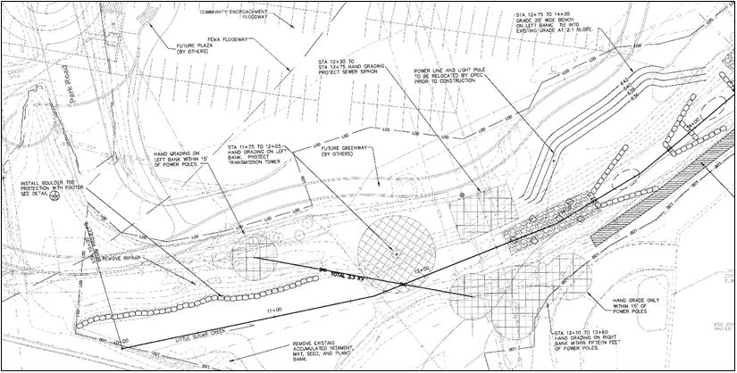
Fig. 10 Little Sugar Creek construction plans, Michael Baker Engineering, Inc. Charlotte, North Carolina (USA), May 12, 2009 (Image courtesy of Crystal Taylor, P.E., Charlotte-Mecklenburg Storm Water Services)
The extensive and intricate nature of the phased project required a collaborative effort to pay for it. Funding partners included: North Carolina Clean Water Management Trust Fund, Department of Water Resources; Mecklenburg County Park & Recreation, Charlotte-Mecklenburg Stormwater Services and the Charlotte Department of Transportation. Fortunately, no changes occurred to the scope of work during the design and implementation of this project [12].
Outcome
“Overall, the project went well and there were no major issues during construction. At the beginning of the construction, the design had to be completely modified in the field because of poor soils that were found in the location of the meander bend. The poor soil is believed to be the sediment deposition that occurred along the original alignment of the stream. The stream design was modified to include a boulder toe to ensure stability in the channel and along the stream bank. An old bridge concrete foundation was discovered during excavation of where the new channel would tie into the original channel just upstream from the former Baxter Street Bridge” [12]. In spite of recreating a more natural channel for Little Sugar Creek – with meanders, in-stream habitat, stable banks, wetlands and floodplains – severe urban constraints caused by dense property lines and utilities have limited the creation of its full natural channel. As a result, Little Sugar Creek is considered in the early stages of partial recovery, but not full recovery. “The creek’s reengineered contours slow down the rushing water, but hard rain can still fill the creek to the top of its banks” [12].
In certain areas, “wetland plants are growing faster than expected, and the presence of fish, insects, frogs and mussels has noticeably increased” [13]. However, ongoing water quality tests reveal that the stream is still polluted. Its upper and lower sections are still rated as “impaired” due to turbidity, copper, fecal coliform and in the upper section, mercury [9]. Even so, there are hopeful signs on the horizon. The estimated average bank erosion rate prior to construction was 88 metric tonnes/year (97 tons/year); the estimated average bank erosion rate after construction is 44.45 metric tonnes/year (49 tons/year) [12].
“There has been very little streambank erosion since the project was constructed. Water quality monitoring in the stream has not been completed on a regular basis because over the last several years there were portions of the overall project under construction. Mecklenburg County’s Water Quality Program has completed fish sampling and found a fish species, called the Tessellated Darter, in the stream that has not been present in this stream in decades.” [12].
Buck Engineering determined at the conclusion of the project that this stream reach currently classifies between a Rosgen B4 and G4. “An absolute Rosgen stream classification of urban streams such as Little Sugar Creek is difficult due to historical channel modification and the limited ability of the channel to freely adjust to its channel-forming agents because of utility and infrastructure constraints.” [8]. Engineers like Barbara Doll, water quality specialist for North Carolina Sea Grant and Crystal Taylor say they realize they can never take Little Sugar Creek back to the conditions of an undisturbed stream. “But do you give up on urban streams all together because you can’t do that?” Doll asks. “We can recover a lot of ecological value to these streams, even in the highly confined spaces of urban watersheds” [13].
Conclusions
Comparing current stream daylighting projects and their spin-off projects with those that were reviewed in 2006 [1], a noticeable progression from very small lengths of stream in fairly open rural and suburban sites to ever more complex, multi-phased downtown urban stream reconstruction are being accomplished. Projects are larger, more collaborative, and far more likely to employ scientific methods of stream assessment, classification and mathematical modeling prior to stream channel construction.
Natural stream channel design principles work effectively within almost all urban environments, even if the level of intervention is different for each stream reach and/or community. The levels of intervention related to site constraints may limit how naturalistic a newly unearthed stream form can take, but they still offer some relief and restoration to parts – if not all – of a stream’s ecological function and health.
In previous case study reviews, it was found that the primary goal behind daylighting appeared to be the creation of a public park or recreation area that would benefit people. Flood control and water quality improvements were secondary. The two case studies presented in this article indicate a potential shift in priorities – flood control and downtown economic development are emerging as driving factors behind restoration efforts, followed closely by improving water quality and expanding habitat corridors. The creation of parks amenities – greenway trails, town “greens” and recreation areas – are dovetailed onto the daylighting projects as an added community benefit (and potential fundraising bonus) but are not the key focus.
From the standpoint of green infrastructure, all the case study projects have successfully reduced urban flooding where it previously occurred along the studied reaches. Daylighting has proved to be a viable green infrastructure alternative to traditional engineering approach, in fact, it is becoming the preferred retrofit method for handling urban flooding in several locations. New stream channels replace failing culverts and underground pipes and greatly reduce dangerous stormwater overflows and flood damage. Even some sections of stream that required repair after significant storm events did not require extensive repairs and none of the case studies to date have reported complete failure
References
- Buchholz T (2006) Urban Stream Daylighting: Case Study Evaluations. Masters’ Thesis. Department of Landscape Architecture, Virginia Tech, Blacksburg, VA.
- Pinkham R (2000) Daylighting: New Life for Buried Streams. Rocky Mountain Institute, Colorado
- National Park Service (Undated) Giving New Life to Streams in Rural City Centers. http://www.nps.gov/ncrc/rivers/projpg/DAYLIGHT.PDF. Accessed 20 September 2006
- Buchholz TA, Madary DA, Bork D, and Younos T (2016) Stream Restoration in Urban Environments: Concept, Design Principles, and Case Studies of Stream Daylighting. In: The Handbook of Environmental Chemistry Vol. 47. Springer Publishers, (ISBN 978-3-319-29335-6). pp. 121-166.
- City of Meriden, CT (2013) Harbor Brook Flood Control Project Overview. http:\\www.cityofmeriden.org. Accessed 12 May 2015.
- Blumenthal R (2014) United States Senator for Connecticut. Blumenthal, Murphy, Esty Announce $2.46 million federal grant to alleviate longtime Meriden flooding. http:\\www.blumenthal.senate.gov/newsroom. Accessed May 12, 2015
- Bass R (2015) Director, Cirty of Meriden, CT, Department of Public Works/Engineering Division. Personal communication
- Buck Engineering (2006) Little Sugar Creek Kings Drive Reach Stream Enhancement Supporting Data. PCN 401/404 Certification Package
- Newsom M (2015) Keeping Watch 2015: An In-Depth Look at the Creeks of Charlotte. http:\\www.keepingwatch.org. Accessed 5 June 2015
- Charlotte-Mecklenburg Storm Water Services (CMSWS) (Undated) Facts and Figures: Urban Little Sugar Creek Greenway. http:\\www.charmeck.org/mecklenburg/county/ParkandRec/Greenways/LittleSugarCreekGreenway/ Documents/ LSCG Fact_Sheet.pdf.
- Taylor C (2015) Charlotte-Mecklenburg Storm Water Services. Personal communication
- North Carolina Clean Water Management (2012) Little Sugar Creek Stream Restoration Project Phase 9 Final Report. North Carolina Clean Water Management Trust Fund Project 2007-404
- Angione K (2007) Cracking the Culvert: Urban Stream Restoration in North Carolina. Coast Watch. http://www.ncseagrant.org. Accessed 5 June 2015
About the Authors:
 Tracy (Buchholz) Strickland, RLA, is Project Manager at Derck & Edson Associates, working on landscape and site design, site planning, master planning, construction documents, land development submissions, consultant coordination, commercial, recreation, and urban design projects.
She also specializes in planting design and custom plant palette development, with special emphasis on native plants. Strickland enjoys working to actively incorporate sustainable design principles and “green infrastructure” components into each project.
Strickland earned Master of Landscape Architecture from Virginia Tech and Bachelor of Urban Studies degree from Rutgers University. She is a member of the American Society of Landscape Architects.

Dr. Tamim Younos is Founder & President of the Green Water-Infrastructure Academy. The mission of the GWI Academy is to enhance human health and quality of life in global urban environments.
He has authored/co-authored more than 150 publications and has edited six books on water science topics.
Younos’s recognitions include: American Water Resources Association Icko Iben Award; Fulbright Award; Universities Council on Water Resources, Friend of UCOWR Award; and Japan Society for Promotion of Science Award.
Younos earned doctoral degrees in urban and environmental engineering from the University of Tokyo and is a former Research Professor of Water Resources at Virginia Tech.