
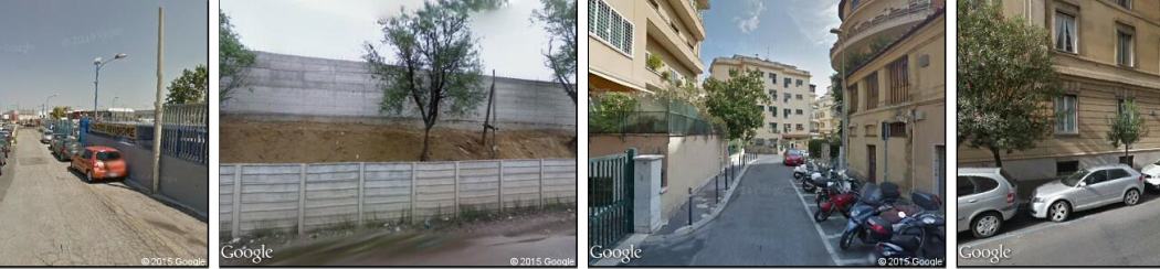
For years, researchers at the Massachusetts Institute of Technology (MIT) Media Lab have been developing a database of images captured at regular distances around several major cities. The images are scored according to different visual characteristics — how safe the depicted areas look, how affluent, how lively, and the like.
In October of 2016, they presented a paper at the Association for Computing Machinery’s Multimedia Conference, together with colleagues at the University of Trento and the Bruno Kessler Foundation, both in Trento, Italy, compared these safety scores, of neighborhoods in Rome and Milan, to the frequency with which people visited these places, according to cellphone data.
Adjusted for factors such as population density and distance from city centers, the correlation between perceived safety and visitation rates was strong, but it was particularly strong for women and people over 50. The correlation was negative for people under 30, which means that males in their 20s were actually more likely to visit neighborhoods generally perceived to be unsafe than to visit neighborhoods perceived to be safe.
In the same paper, the researchers also identified several visual features that are highly correlated with judgments that a particular area is safe or unsafe.
Consequently, the work could help guide city planners in decisions about how to revitalize declining neighborhoods.
From the paper’s Introduction: Does a neighborhood’s appearance of safety affect how active it is? For decades scholars from a variety of disciplines, but mainly from urban planning, have been exploring the potential connection between a neighborhood’s appearance of safety and its levels of human activity.
The modern literature connecting safety, liveliness, and architecture, can be traced back to Jane Jacobs’ seminal 1961 book: The Death and Life of Great American Cities. In there, Jacobs introduced the eyes-on-the-street, or natural surveillance hypothesis, which suggests that citizens can maintain the safety of their neighborhoods naturally through continued surveillance. For natural surveillance to take place, however, Jacobs argued that neighborhoods needed to have certain physical qualities, such as well lit streets and buildings with street facing windows.
Jacobs’ idea that the physical quality of a neighborhood can enhance its safety was later expanded by Oscar Newman’s defensible space theory. Defensible space theory expands on the idea of natural surveillance by suggesting that neighbors will be more likely to protect an area when there are clear physical demarcations separating what is considered public and private property.
Examples of architectural markers of defensible space are archways in the entrance of building complexes, or staircases in the entrance of townhouses. These archways and staircases do not only serve an aesthetic purpose, but also, signal the boundary between a city’s public space and the private and semi-private spaces that neighbors are expected to watch and defend.
Here, we strengthen the link between Jacobs’ and Newman’s theories by asking whether safer looking neighborhoods are more likely to experience more human activity–and hence,
experience more natural surveillance. We explore this connection, by combining computer vision methods, that can be used to measure the physical characteristics of neighborhoods, with mobile phone data, which has become a common proxy for human activity, for two Italian cities (Rome and Milan).
The combination of computer vision and mobile phone data helps us test whether safer looking neighborhoods are more active, and therefore, if neighborhoods that look physically safer could be experiencing more natural surveillance. Our data provides support for a connection between appearance and activity. Using spatially filtered multivariate
regressions we find that neighborhoods that are perceived as safer are more active than what is expected from their population density, the density of employees, and their distance to the city center.
Also, we find that the perception of safety appears to modulate the relative population of females and adults, with unsafer looking neighborhoods experiencing a lower number of female and people over 50 than safer looking neighborhoods. Conversely, we find that younger populations are disproportionately more active in unsafe looking neighborhoods.
Finally, we use occlusion techniques to identify the areas of an image that trigger a positive or negative evaluation of safety in the Artificial Neural Network, finding that greenery and street facing windows tend to be associated with higher levels of safety, as suggested by Oscar Newman’s defensible space theory. These observational results strongly suggest–but don’t causally prove–that the appearance of neighborhoods has an effect on their levels of human activity, and potentially, on a neighborhood’s level of
natural surveillance.
Note from Storm: Those who have attended on of my talks or workshops in recent years, or who have read my Resilience Strategy Guide, know that I have long advocated a simple measuring of pedestrian activity as a rough gauge of revitalization, or the need thereof. This excellent new research follows much the same approach.