
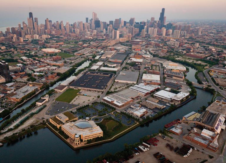
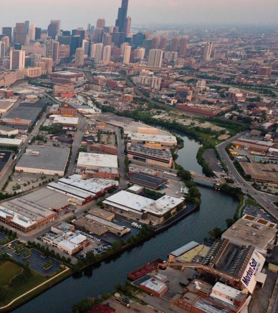
On May 8, 2017, Chicago, Illinois Mayor Rahm Emanuel and the Department of Planning and Development released the final draft of the North Branch Industrial Corridor Framework. The Framework is designed to respond to current business needs to revitalize the area as a mixed-use employment center while creating new resources for industrial development citywide.
 The plan is expected to unleash billions of dollars of private investment in the redevelopment of this 3.7-mile stretch along the Chicago River, along with public investment in new sports fields, bridges, a new Metra transit station, and other infrastructure.
“This plan represents countless hours of community input and thoughtful planning designed to balance the needs of community members and local businesses while paving the way to a bright future for the North Branch Industrial Corridor,” Mayor Emanuel said. “In addition to building a new future for the North Branch area, this framework will also generate revenue from this thriving area to support industrial businesses throughout Chicago. Now we move forward to the next step in the process, which will bring together the North Branch stakeholders to turn this plan into concrete progress for the community.”
 The North Branch framework is the first phase of Mayor Emanuel’s Industrial Corridor Modernization Initiative, which is reviewing all 26 of the City’s designated industrial corridors for improvements involving land use, infrastructure, transportation, and public amenities that have not been systematically assessed in nearly three decades.
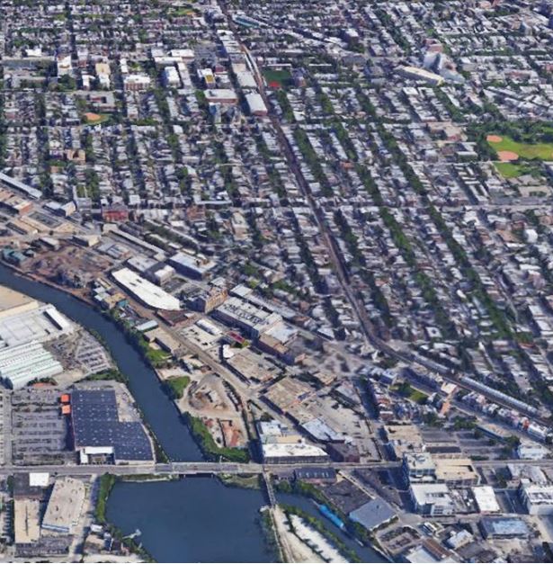
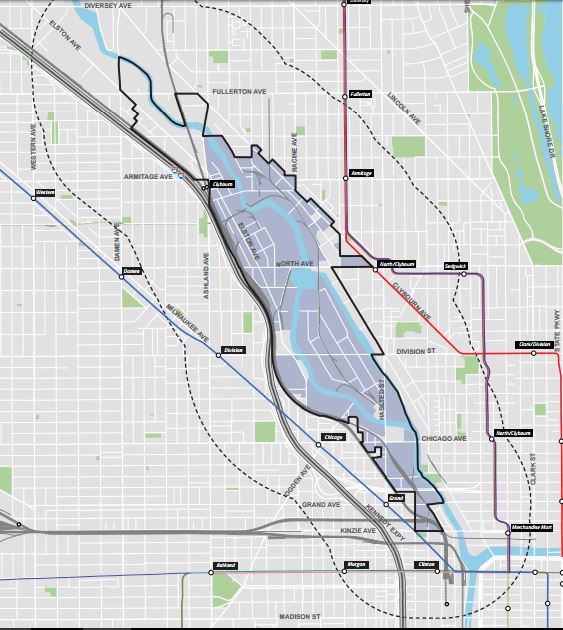
The North Branch Industrial Corridor encompasses 760 acres of primarily industrial land along the river between Kinzie Street and Fullerton Avenue. The area supports approximately 15,000 jobs, of which just 10 percent remain in manufacturing, due to large parcels of vacant land, antiquated infrastructure, and outdated land use regulations that inhibit the corridor’s role as an employment center for the entire city.
 “The year-long North Branch community engagement process has produced a thoughtful, considered and balanced framework that will protect existing businesses and generate hundreds of millions of dollars of new investment and redevelopment activity, millions of dollars in new taxes, and tens of thousands of new jobs, as well as critical transportation and open space enhancements that will serve area workers, residents and visitors for decades to come,” said Planning and Development Commissioner David L. Reifman. “At the same time, the framework plan has the potential to generate tens of millions of dollars to support industrial and neighborhood development for other parts of the city.”
The North Branch planning process initiated in the spring of 2016 identified three main goals for corridor improvements: Maintain the North Branch as an important economic engine and vital job center; provide better access for all transportation modes; and build upon the corridor’s unique natural and built environment.
 The Framework also includes implementation strategies that will fund local and citywide improvements, as well as design guidelines that will help maintain the corridor’s uniquely urban character.
The plan’s implementation over the next 20 years could triple the local employment base, create tens of thousands of construction jobs, add several thousand new residents, and generate hundreds of millions of dollars in economic activity.
The extensive community engagement process included more than 800 participants at 18 community meetings, more than 100 written comments, numerous individual meetings within local stakeholders, and other mapping and planning activities.
 As a framework for growth and investment, the plan establishes land use recommendations and planning goals that will help guide the review of future development projects by the Chicago Plan Commission and the City Council. Individual projects will also undergo community-level review coordinated with local aldermen.
“The public process in the North Branch determined there’s a wide recognition for land use improvements in the corridor,” said Eleanor Gorski, DPD deputy commissioner for planning, design and historic preservation. “It also identified numerous competing goals from different user groups and stakeholders that the plan successfully balances on behalf of the planning area as well as the entire city.”
Major planning principles include:
LAND USE:
- Target more than 50 percent of corridor land for employment purposes;
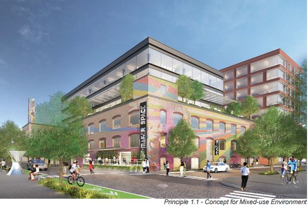
- Allow new mixed-use development at appropriate locations with provisions for affordable housing and publicly accessible open space;
- Increase allowable density and height while creating high-quality publicly accessible open spaces and non-vehicular transportation improvements;
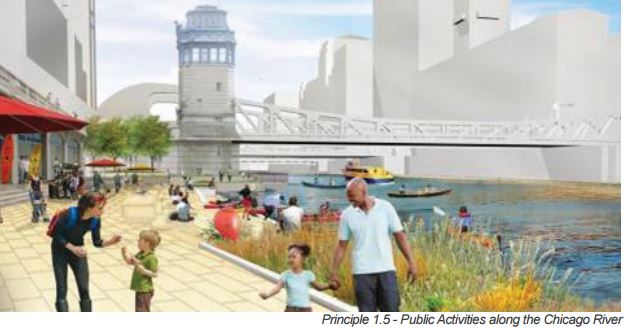
- Encourage new uses at the bases of buildings along the river to encourage public activities.
TRANSPORTATION:
- Reconfigure roadways, viaducts, and bridge reconstruction projects to help manage traffic circulation;
- Build a dozen new pedestrian/bike bridges and under-bridge connections along the river to increase the effectiveness of the area’s five transit stations;
- Extend the 606 multi-purpose path over the river;
- Leverage technologies like “smart signals” and real-time displays to minimize peak travel times;
- Study a dedicated public transit-way on existing rail corridors and other rights-of-way.
OPEN SPACE:
- Build 32 acres of linear park space as part of a new, seven-mile river trail, consistent with Mayor Emanuel’s vision of enhancing the river as Chicago’s next recreational frontier;
- Incorporate at least 10 acres of new publicly accessible open spaces for sports and recreational fields;
- Add a one-acre park as part of a 606 connection with the river trail;
- Create 17 acres of wetland parks.
IMPLEMENTATION:
Framework implementation would include review and approval of the Chicago Plan Commission on May 18, 2017. The framework would then be used by City Council to consider initial zoning changes recommended in the plan. City Council would also consider Planned Developments (PD) and other zoning changes proposed by private developers and property owners in the years to come.
The initial zoning changes are intended to reset the baseline for further development proposals and to accommodate necessary land use transitions in the North Branch area. The area has been characterized by exponential increases in business service, high-tech, management and related office employment within the corridor since 1988. Over that time, manufacturing jobs decreased more than half to approximately 1,500 jobs, resulting in large, vacant parcels of land within corridor boundaries, as well as other under-performing sites that are limited by existing zoning.
Initial zoning recommendations seek to:
- Change existing Planned Manufacturing District (PMD) zoning in the north portion of the corridor to Manufacturing (M), which would permit existing uses and accommodate transitions to mixed-use office, commercial and residential uses at appropriate locations;
- Maintain and refine existing Planned Manufacturing District (PMD) zoning in the central portion of the corridor, largely around Goose Island;
- Change existing Planned Manufacturing District (PMD) zoning in the southern portion of the corridor to Downtown Service (DS), which would permit existing uses and accommodate transitions to downtown-type mixed-use commercial and residential uses nearby;
- Establish an overlay district and other land use parameters that identify buffer areas, use restrictions, and density regulations to ensure new development projects enhance the corridor’s overall development patterns and function.
FUNDING APPROACH:
The plan recommends several new and existing funding tools to finance proposed improvements within the corridor as well as other parts of the city:
- A new Industrial Corridor System Fee would apply to projects in the North Branch and other corridors that are transitioning from PMD/manufacturing to other uses, triggered by private applications for a zoning change away from industrial zoning. Similar to the way Mayor Emanuel has successfully leveraged resources with the new Neighborhood Opportunity Fund, redevelopment within the North Branch could generate tens of millions of new revenues to support industrial improvement projects in other industrial corridors throughout the city;
- A new Zoning Bonus system in the northern portion of the corridor would enable new projects to seek increased density through a voluntary payment. The payment would primarily support local improvements within the North Branch area, as well as contribute to vital projects in industrial corridors throughout other parts of the city;
- Application of the existing downtown Zoning Bonus system for the southern portion of the corridor, available through a change to Downtown (DX) mixed-use zoning, will result in tens of millions of additional dollars for the Mayor’s Neighborhood Opportunity Fund, to invest in commercial development on the city’s South and West Sides;
- Planned Development (PD) contributions that would provide or contribute to publicly accessible open space, river walks, traffic signals, roads, and other infrastructure costs;
- Other city, state, and federal sources.